Brookwood, Alabama
Brookwood is a town in Tuscaloosa County, Alabama, United States. It incorporated in September 1977.[5] As of the 2010 census, the population of the town is 1,828.[3] It is part of the Tuscaloosa, Alabama Metropolitan Statistical Area.
Brookwood | |
|---|---|
| Brookwood, Alabama[1] | |
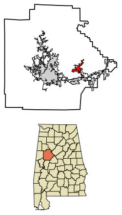 Location of Brookwood in Tuscaloosa County, Alabama. | |
| Coordinates: 33°14′20″N 87°19′11″W | |
| Country | United States |
| State | Alabama |
| County | Tuscaloosa |
| Area | |
| • Total | 8.46 sq mi (21.91 km2) |
| • Land | 8.37 sq mi (21.68 km2) |
| • Water | 0.09 sq mi (0.24 km2) |
| Elevation | 600 ft (200 m) |
| Population | |
| • Total | 1,828 |
| • Estimate (2019)[4] | 1,848 |
| • Density | 220.79/sq mi (85.25/km2) |
| Time zone | UTC-6 (Central (CST)) |
| • Summer (DST) | UTC-5 (CDT) |
| ZIP code | 35444 |
| Area code(s) | 205, 659 |
| FIPS code | 01-09808 |
| GNIS feature ID | 0114971 |
| Website | Town of Brookwood |
Demographics
| Historical population | |||
|---|---|---|---|
| Census | Pop. | %± | |
| 1970 | 196 | — | |
| 1980 | 492 | 151.0% | |
| 1990 | 658 | 33.7% | |
| 2000 | 1,483 | 125.4% | |
| 2010 | 1,828 | 23.3% | |
| Est. 2019 | 1,848 | [4] | 1.1% |
| U.S. Decennial Census[6] 2013 Estimate[7] | |||
At the 2000 census there were 1,483 people, 553 households, and 430 families living in the town. The population density was 182.3 people per square mile (70.4/km2). There were 613 housing units at an average density of 75.4 per square mile (29.1/km2). The racial makeup of the town was 97.91% White, 0.54% Black or African American, 0.07% Native American, 0.13% Asian, 0.20% from other races, and 1.15% from two or more races. 0.34% of the population were Hispanic or Latino of any race.[8] Of the 553 households 42.1% had children under the age of 18 living with them, 63.3% were married couples living together, 9.4% had a female householder with no husband present, and 22.2% were non-families. 19.2% of households were one person and 6.7% were one person aged 65 or older. The average household size was 2.68 and the average family size was 3.07.
The age distribution was 28.9% under the age of 18, 8.7% from 18 to 24, 33.1% from 25 to 44, 21.8% from 45 to 64, and 7.5% 65 or older. The median age was 34 years. For every 100 females, there were 99.1 males. For every 100 females age 18 and over, there were 96.5 males.
The median household income was $40,104 and the median family income was $46,071. Males had a median income of $38,929 versus $23,571 for females. The per capita income for the town was $18,670. About 6.2% of families and 8.2% of the population were below the poverty line, including 10.1% of those under age 18 and 5.4% of those age 65 or over.
2010 census
At the 2010 census there were 1,828 people, 659 households, and 516 families living in the town. The population density was 225.7 people per square mile (86.3/km2). There were 703 housing units at an average density of 86.8 per square mile (33.3/km2). The racial makeup of the town was 92.2% White, 5.3% Black or African American, 0.7% Native American, 0.1% Asian, 0.4% from other races, and 1.4% from two or more races. 2.0% of the population were Hispanic or Latino of any race.[9] Of the 659 households 38.1% had children under the age of 18 living with them, 59.6% were married couples living together, 12.9% had a female householder with no husband present, and 21.7% were non-families. 17.8% of households were one person and 5.2% were one person aged 65 or older. The average household size was 2.77 and the average family size was 3.11.
The age distribution was 27.3% under the age of 18, 9.9% from 18 to 24, 33.1% from 25 to 44, 22.6% from 45 to 64, and 7.1% 65 or older. The median age was 32 years. For every 100 females, there were 93.2 males. For every 100 females age 18 and over, there were 93.1 males.
The median household income was $55,357 and the median family income was $66,944. Males had a median income of $44,837 versus $31,118 for females. The per capita income for the town was $19,352. About 7.2% of families and 10.6% of the population were below the poverty line, including 12.1% of those under age 18 and 5.2% of those age 65 or over.
Climate
The climate in this area is characterized by hot, humid summers and generally mild to cool winters. According to the Köppen Climate Classification system, Brookwood has a humid subtropical climate, abbreviated "Cfa" on climate maps. [10]
| Climate data for Brookwood, Alabama | |||||||||||||
|---|---|---|---|---|---|---|---|---|---|---|---|---|---|
| Month | Jan | Feb | Mar | Apr | May | Jun | Jul | Aug | Sep | Oct | Nov | Dec | Year |
| Average high °C (°F) | 11 (52) |
14 (57) |
19 (66) |
24 (75) |
28 (82) |
32 (89) |
33 (91) |
33 (91) |
30 (86) |
24 (76) |
19 (66) |
13 (56) |
23 (74) |
| Average low °C (°F) | −1 (30) |
1 (33) |
4 (40) |
9 (48) |
13 (56) |
18 (64) |
20 (68) |
19 (67) |
17 (62) |
9 (49) |
5 (41) |
1 (34) |
9 (49) |
| Average precipitation mm (inches) | 140 (5.7) |
130 (5.2) |
150 (6) |
120 (4.7) |
110 (4.4) |
120 (4.7) |
140 (5.5) |
99 (3.9) |
100 (4) |
81 (3.2) |
120 (4.7) |
120 (4.9) |
1,440 (56.8) |
| Source: Weatherbase [11] | |||||||||||||
References
- Code of Alabama 1975, Title 11, Chapter 40, Section 11-40-1 Archived 2010-03-17 at the Wayback Machine
- "2019 U.S. Gazetteer Files". United States Census Bureau. Retrieved June 29, 2020.
- "U.S. Census website". United States Census Bureau. Retrieved 2014-10-23.
- "Population and Housing Unit Estimates". United States Census Bureau. May 24, 2020. Retrieved May 27, 2020.
- http://www.encyclopediaofalabama.org/article/h-3405
- "U.S. Decennial Census". Census.gov. Retrieved June 6, 2013.
- "Annual Estimates of the Resident Population: April 1, 2010 to July 1, 2013". Archived from the original on May 22, 2014. Retrieved June 3, 2014.
- "U.S. Census website". United States Census Bureau. Retrieved 2008-01-31.
- "U.S. Census website". United States Census Bureau. Retrieved 2015-08-13.
- Climate Summary for Brookwood, Alabama
- "Weatherbase.com". Weatherbase. 2013. Retrieved on November 6, 2013.
External links
Municipalities and communities of Tuscaloosa County, Alabama, United States | ||
|---|---|---|
| Cities | 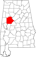 Map of Alabama highlighting Tuscaloosa County | |
| Towns | ||
| CDP | ||
| Unincorporated communities | ||
| Ghost town | ||
| Footnotes | ‡This populated place also has portions in an adjacent county or counties | |