Borumba Dam
The Borumba Dam is a rock-fill embankment dam with an un-gated spillway located across the Yabba Creek in the Wide Bay–Burnett region of Queensland, Australia. The main purposes of the dam are for irrigation and potable water supply.[2][3] The resultant impounded reservoir is called Lake Borumba.[1]
| Borumba Dam | |
|---|---|
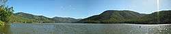 A panorama of Lake Borumba | |
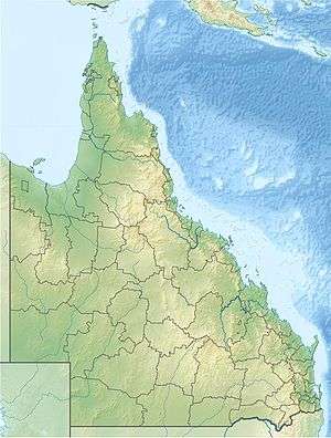 Location of the Borumba Dam in Queensland | |
| Country | Australia |
| Location | Wide Bay–Burnett, Queensland |
| Coordinates | 26°30′43″S 152°34′44″E |
| Purpose | Irrigation and potable water supply |
| Status | Operational |
| Opening date | 1963; upgraded in 1997 and 2009 |
| Operator(s) | SEQ Water |
| Dam and spillways | |
| Type of dam | Embankment dam |
| Impounds | Yabba Creek |
| Height | 43 m (141 ft) |
| Length | 343 m (1,125 ft) |
| Dam volume | 402×103 m3 (14.2×10⁶ cu ft) |
| Spillway type | Uncontrolled |
| Spillway capacity | 3,140 m3/s (111,000 cu ft/s) |
| Reservoir | |
| Creates | Lake Borumba |
| Total capacity | 46,000 ML (1,600×106 cu ft)[1] |
| Catchment area | 465 km2 (180 sq mi) |
| Surface area | 480 ha (1,200 acres) |
| Maximum water depth | 6.6 m (22 ft) |
| Website www.seqwater.com.au | |
Location and features
Constructed in 1964, Borumba Dam is one of Queensland's most established lakes. The dam wall is located about 11 kilometres (6.8 mi) south west of Imbil.
The dam wall is 43 metres (141 ft) high and 343 metres (1,125 ft) long and holds back 46,000 megalitres (1,600×106 cu ft) of water when at full capacity. The surface area of the reservoir is 480 hectares (1,200 acres) and the catchment area is 465 square kilometres (180 sq mi). The uncontrolled un-gated spillway has a discharge capacity of 3,140 cubic metres per second (111,000 cu ft/s).[1][3] The dam is managed by Seqwater. The dam wall was raised by 2.5 metres (8 ft 2 in) and completed in 1997. During 2008 and 2009 the dam wall was raised by another 1.6 metres (5 ft 3 in).[4] The second upgrade was intended to allow better management of extreme rainfall events.[5]
According to a local councillor the spillway developed a crack after an earthquake on 1 December 1991.[6]
Recreation
A range of recreation activities are permitted at Borumba Dam including boating (powered and non-powered), canoeing and kayaking, water skiing and jet skiing, fishing, camping, and walking. Picnic and barbeque facilities are available.
Naturally occurring blue-green algae blooms sometimes mean Seqwater closes access to the dam's water for public safety purposes.[7]
See also
- List of dams in Queensland
- Stuart Gatehouse, whose remains were found in the lake
References
- "Borumba Dam". Water supply: Dams and weirs. Seqwater. 2014. Retrieved 27 June 2014.
- Harrison, Rod; James, Ernie; Sully, Chris; Classon, Bill; Eckermann, Joy (2008). Queensland Dams. Bayswater, Victoria: Australian Fishing Network. p. 94. ISBN 978-1-86513-134-4.
- "Register of Large Dams in Australia" (Excel (requires download)). Dams information. Australian National Committee on Large Dams. 2010. Retrieved 23 June 2014.
- "Spillways step up for assessment". International Dam and Power Construction. Global Trade Media. 16 June 2010. Retrieved 26 September 2012.
- "Borumba Dam upgrade won't include storage boost". ABC News. Australia. 9 April 2008. Retrieved 26 September 2012.
- Green, Glenis (30 January 2007). "Fault line on dam site". The Courier-Mail. Retrieved 26 September 2012.
- "Dam recreation shut down". The Gympie Times. 13 January 2012. Retrieved 26 September 2012.
External links
- Borumba Dam Fishing Information, Map, pictures & Water Level Gauge
- Pictures- National Library of Australia
Water supply in Queensland, Australia | |||||||||||||
|---|---|---|---|---|---|---|---|---|---|---|---|---|---|
| |||||||||||||
| |||||||||||||