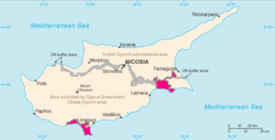
Borders of Akrotiri and Dhekelia
The borders of Akrotiri and Dhekelia refer to the international boundary between the Sovereign Base Areas of Akrotiri and Dhekelia (a British overseas territory) and the republic of Cyprus.
| Borders of Akrotiri and Dhekelia | |
|---|---|
 The borders, as seen on the map | |
| Characteristics | |
| Entities | Akrotiri and Dhekelia ( Non-sovereign entities and unrecognised states: |
| Length | 156 kilometres (96.9 mi) |
| History | |
| Established | 1960 London-Zürich Agreements |
| Treaties | London-Zürich Agreements (Appendix O) |
The SBAs consist of two enclaves in the island of Cyprus. The border of Akrotiri is 48 km (30 mi),[1] and the border of Dhekelia is 108 km (67 mi).[2] Dhekelia is also bound by the UN Buffer Zone and the unrecognised state in Northern Cyprus.
History
Customs and identity checks
Possession of a passport, or an EU compliant national identity card is generally needed in Cyprus.
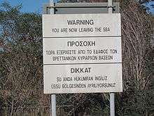
There is no "hard" land border with Cyprus, and entry to the public areas of both SBAs can be done without any difficulty.[3] In the exchange of notes establishing them the British government specifically stated that it would not, "...create customs posts or other frontier barriers between the Sovereign Base Areas and the Republic."[4] More formal controls do exist at the Republic of Northern Cyprus boundary.[5]
A passport is required to travel between Cyprus/SBAs and Northern Cyprus. Issues concerning the validity of car insurance and customs are specified by SBAs' administration.[6]
References
- "Europe :: Akrotiri — The World Factbook - Central Intelligence Agency". www.cia.gov.
- "Europe :: Dhekelia — The World Factbook - Central Intelligence Agency". www.cia.gov.
- Akrotiri and Dhekelia
- TREATY NO. 5476. UNITED KINGDOM OF GREAT BRITAIN AND NORTHERN IRELAND, GREECE and TURKEY and CYPRUS
- Customs and Immigration
- SBA Customs and Immigration Travelling to Northern Cyprus
| History |
|  | ||||||||
|---|---|---|---|---|---|---|---|---|---|---|
| Geography |
| |||||||||
| Politics | ||||||||||
| Economy | ||||||||||
| Society |
| |||||||||