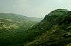
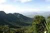
Bodamalai Betta
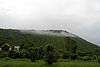
Bodamalai Betta is a 1,200 metres (3,937.0 ft) mountain in the Eastern Ghats of South India. It is in the hills 20 kilometres (12.4 mi) west of the Stanley Reservoir in Salem District of Tamil Nadu state, India.
Bodamalai Betta Bodamalai Mountain | |
|---|---|
Reserve forest | |
 Bodamalai Betta Location in Tamil Nadu, India | |
| Coordinates: 11.914167°N 77.554444°E | |
| Country | India |
| State | Tamil Nadu |
| District | Salem District |
| Governing body | Tamil Nadu Forest Department |
| Talukas | Mettur |
| Languages | |
| • Official | Tamil |
| Time zone | UTC+5:30 (IST) |
| Nearest city | WxNW of Mettur (29.6 km (18.4 mi)) |
| IUCN category | V |
| Drainage basin: | Palar River |
| Highest_elevation | 1,200 m (3,900 ft) AMSL[1] |
| Public access: | off-trail trekking year-round, free, no services |
| Climate | Cwa (Köppen) |
| Precipitation | 1,600 millimetres (63 in) |
| Avg. summer temperature | 33.2 °C (91.8 °F) |
| Avg. winter temperature | 15.1 °C (59.2 °F) |
| Rainfall:[2] | |
Geography
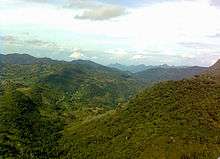
Elevation is 1,200 metres (3,937.0 ft). It is the tallest of a distinct area of hills covering an area about10 km (6.2 mi) east-west and 7 km (4.3 mi) km north-south, all with elevation below600 metres (1,968.5 ft), surrounded by valleys on the south, west and north and plains to the east. Bodamalai Betta is in a strong (VI) earthquake zone, with on average one every 50 years, with magnitude of 5-6 on the Richter magnitude scale.[3][4]
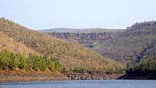
3 kilometres (1.9 mi) to the north of the peak is the east-west valley of the Palar River, a minor tributary of the Kaveri River There is a local road along the river.[1][3]
The nearest town is Chinna Cottai18 kilometres (11 mi) by road in Chamarajanagar district, Karnataka state.
Climate
Bodamalai Betta is in an area with a Humid subtropical climate. April is warmest month with an average temperature of 91.76 °F (33.20 °C) at noon. January is coldest with an average temperature of 59.18 °F (15.10 °C) at night. Temperatures drop sharply at night. February is on average the month with most sunshine. Rainfall and other precipitation peaks around October. January is the driest month.[4]
References
- "29.6 km WxNW of Mettur", ACME Mapper 2.0, ACME Laboratories, Tele Atlas, retrieved 20 January 2011
- A. Subburaj ( Scientist - D) (December 2008), "DISTRICT AT A GLANCE (SALEM DISTRICT)" (PDF), DISTRICT GROUNDWATER BROCHURE - SALEM DISTRICT, TAMIL NADU - Technical Report Series, Chennai: Government of India, Ministry of Water Resources, Central Ground Water Board, South Eastern Coastal Region, p. 1, retrieved 24 February 2012
- Bodamalai Betta: India, Bethesda, Maryland, USA: National Geospatial-Intelligence Agency, retrieved 20 January 2011
- Bodamalai Betta (mountain), archived from the original on 4 March 2016, retrieved 24 February 2012
External sources
- "Southern Indian Subcontinent: 4 Mountain Summits with Prominence of 1,500 meters or greater" Peaklist.org. Retrieved 2011-11-24
| Branches |
| ||||||
|---|---|---|---|---|---|---|---|
| Techniques and tools | |||||||
| Institutions |
| ||||||
| Education |
| ||||||
| |||||||
 | ||
| ||