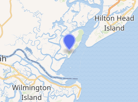
Bloody Point Range Lights
The Bloody Point Range Lights, which is known as the Bloody Point Lighthouse, were range lights on the southern end of Daufuskie Island in Beaufort County, South Carolina. The Bloody Point Range Lights were built in 1883. Due to erosion, the front light was moved to the location of the former rear light and became the rear light. The lights were maintained as an official aid to navigation until 1922. The original Front Range Light house is currently a private home.[2][3]
 | |
| |
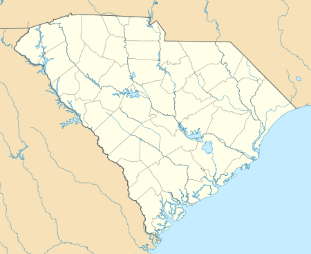
| Location | South Carolina, US |
|---|---|
| Coordinates | 32°05′49.7″N 80°52′23.5″W |
| Year first constructed | 1883 |
| Year first lit | 1883 |
| Deactivated | 1922 |
| Construction | Wood |
| Tower shape | Dormer window on roof of house |
| Tower height | 27 feet (8.2 m) (Original Front) 91 feet (28 m) (Original Rear) |
| Focal height | 81 feet (25 m) (Original Rear) |
| Original lens | Red steamer lens (Front and Rear) |
| Current lens | Decorative |
| Heritage | NRHP contributing property |
Bloody Point Lighthouse | |
| Part of | Daufuskie Island Historic District (ID82003831) |
| Added to NRHP | June 2, 1982[1] |
Bloody Point is the southern end of Daufuskie Island. It was given this name because of the blood shed during the Yamasee War of 1715.[4]
Original range lights
In 1871, the U.S. Congress authorized two sets of range lights on Daufuskie Island. The other range lights were the Haig Point Range Lights on the northern end of the island. In 1882, 6.72 acres (2.72 ha) was purchased for the Bloody Point lights.[2][3]
The Front Range Light was a red, kerosene lamp placed in a gable-fronted dormer window of the lightkeeper's house. This house, which was built by James C. LaCoste, was located near the beach on 1.72 acres (7,000 m2). The light was at a height of 27 feet (8.2 m).[2][5]
The Rear Light was a 91-foot (28 m) tall triangular, iron skeletal tower, manufactured by the Cooper Manufacturing of Mount Vernon, Ohio. John Michael Doyle, who was an employee of the manufacturer, supervised the erection of the tower on a concrete foundation on 5 acres (2.0 ha) plot about 4,350 feet (1,330 m) inland of the front light. Doyle became the first light keeper. A brick lamp house, which was also called a wick house, was built at the base of the tower to house the lamp during the day. At night, the red steamer lamp with parabolic reflector was raised on rails to a height of 81 feet (25 m). The Bloody Point Range Lights were lit on 1883.[2] A nearby brick oil house for storage of kerosene was also built.[6]
Later configuration
Due to erosion, the front light was moved in 1899 to a location near the rear light, which was dismantled. In its new position, it became the rear light. A 45 feet (14 m) tall wooden house on metal legs was placed on leased land near the shore. The metal legs rested on metal disks that could be slid across the beach as the channel shifted. This light was moved several times over the next twenty years. The range lights were deactivated in 1922.[2][3][7][8]
In 1925, the lightkeeper house was sold.[9] The front range light had already been lost due to erosion. The house was sold at auction and then sold to its last light keeper, Gus Ohman. In 1926, he sold it to a former assistant light keeper, Arthur A. "Papy" Burn, Jr., who lived there for about 40 years. In 1953, Papy Burn started making wine using blackberries, elderberries, scuppernongs, and other fruit in the lamp house [3][10] and/or the oil house.[2][11] Although wine making was a small operation, he called the building the Silver Dew Winery. Two small brick buildings with the sign for the Silver Dew Winery were described by Pat Conroy in his autobiographical book the Water is Wide.[12][13]
In 1981, the house was renovated as a private home. The property was seized for back taxes owed and sold. It was purchased in an auction at the Beaufort County Courthouse in 1983. After serving as a temporary pro shop for a golf course, it is now a private residence.[2][10]
The former Front Range House is a contributing property of the National Register of Historic Places' Daufuskie Island Historic District. The nomination form and an additional pictures are available from the South Carolina Department of Archives and History.[14][15]
References
- "National Register Information System". National Register of Historic Places. National Park Service. April 15, 2008.
- Burn, Billie, An Island Named Daufuskie, The Reprint Company, Inc., Spartanburg, SC, 1991, pp. 187-203, ISBN 0-87152-454-6.
- Clary, Margie Willis, The Beacons of South Carolina, Sandlapper Publishing Co., Inc., Orangeburg, SC, 2005, pp. 59-67, ISBN 0-87844-176-X.
- Edgar, Walter, The South Carolina Encyclopedia, University of South Carolina Press, Columbia, SC, 2006, p. 247, ISBN 1-57003-598-9.
- "Bloody Point Lighthouse" (PDF). Beaufort County Historical Survey - 1997. Beaufort County, South Carolina. Retrieved 2008-07-16.
- "Bloody Point Lighthouse, Oil House" (PDF). Beaufort County Historical Survey - 1997. Beaufort County, South Carolina. Retrieved 2008-07-16.
- "Historic Light Station Information and Photography: South Carolina". United States Coast Guard Historian's Office. Archived from the original on 2017-05-01. Retrieved 2008-07-14.
- Roberts, Bruce, and Jones, Ray, Southern Lighthouses: Outer Banks to Cape Florida, 3rd ed., Globe Pequot Press, Guildord, CT, 2002, pp. 48-49, ISBN 0-7627-1243-0.
- Zepke, Terrance, Lighthouse of the Carolinas, Pineapple Press, Sarasota, FL, 2002, pp. 153-157, ISBN 1-56164-148-0.
- "History of the Bloody Point Lighthouse". Low Country Joe's website. www.lowcountryjoe.com. Archived from the original on 2008-05-11. Retrieved 2008-07-17.
- Bansemer, Roger, Bansemer's Book of Carolina & Georgia Lighthouses, Pineapple Press, Sarasota, FL, 2000, pp. 96-97, ISBN 1-56164-194-4.
- "Bloody Point Front Range, SC". The Lighthouses. Lighthousefriends.com. Archived from the original on 2007-10-13. Retrieved 2008-07-18.
- Conroy, Pat, The Water is Wide, Houghton Mifflin Company, Boston, MA, 1972, p. 69, ISBN 0-395-13644-X.
- "Daufuskie Island Historic District" (PDF). National Register of Historic Places Inventory - Nomination Form. South Carolina Department of Archives and History. Retrieved 2008-07-14.
- "Daufuskie Island Historic District". South Carolina Department of Archives and History. Retrieved 2008-07-14.
