Blawenburg, New Jersey
Blawenburg is an unincorporated community and census-designated place (CDP) located within Montgomery Township, in Somerset County, New Jersey, United States.[10][11][12] As of the 2010 United States Census, the CDP's population was 280.[4] It is located at the juncture of two large roads, CR 518 and CR 601. It contains the Blawenburg Cemetery and the Blawenburg Reformed Church.The area that was eventually known as Blawenburg was settled by John Blaw prior to 1742 when he purchased 400 acres of farmland from Abraham Van Horn, a merchant of New York City and a large New Jersey landholder, and 95 acres adjacent to this tract from Nicholas Lake of New Brunswick, NJ. John's father was Jan Frederickse Blaw, a refugee from Holland, born in Recife, Pernambuco, Brazil, who settled in New Amsterdam where John Blaw was born. John had a son Michael who ran a mill at the point where the Great Road crosses Beden's Brook, and it is believed that Blaw's Mill was the origin of the name Blawenburg.
Blawenburg, New Jersey | |
|---|---|
 Blawenburg Reformed Church | |
 Blawenburg, New Jersey Location of Blawenburg within Somerset County, New Jersey. (Inset: Location of Somerset County in New Jersey).  Blawenburg, New Jersey Blawenburg, New Jersey (New Jersey)  Blawenburg, New Jersey Blawenburg, New Jersey (the United States) | |
| Coordinates: 40.402646°N 74.698566°W[1][2] | |
| Country | |
| State | |
| County | Somerset |
| Township | Montgomery |
| Area | |
| • Total | 0.612 sq mi (1.586 km2) |
| • Land | 0.608 sq mi (1.575 km2) |
| • Water | 0.004 sq mi (0.011 km2) 0.69% |
| Elevation | 118 ft (36 m) |
| Population | |
| • Total | 280 |
| • Density | 460.4/sq mi (177.8/km2) |
| Time zone | UTC-5 (Eastern (EST)) |
| • Summer (DST) | UTC-4 (Eastern (EDT)) |
| ZIP code | |
| Area code(s) | 609/640 and 732/848 |
| FIPS code | 3406190[1][7][8] |
| GNIS feature ID | 02583970[1][9] |
Geography
According to the United States Census Bureau, Blawenburg had a total area of 0.612 square miles (1.586 km2), including 0.608 square miles (1.575 km2) of land and 0.004 square miles (0.011 km2) of water (0.69 percent).[1][2]
Demographics
| Historical population | |||
|---|---|---|---|
| Census | Pop. | %± | |
| 2010 | 216 | — | |
| Population sources: 2010[4] | |||
Census 2010
The 2010 United States Census counted 280 people, 107 households, and 72.974 families in the CDP. The population density was 460.4 per square mile (177.8/km2). There were 115 housing units at an average density of 189.1 per square mile (73.0/km2). The racial makeup was 75.36% (211) White, 0.00% (0) Black or African American, 0.00% (0) Native American, 19.29% (54) Asian, 0.00% (0) Pacific Islander, 0.00% (0) from other races, and 5.36% (15) from two or more races. Hispanic or Latino of any race were 1.43% (4) of the population.[4]
Of the 107 households, 31.8% had children under the age of 18; 61.7% were married couples living together; 4.7% had a female householder with no husband present and 31.8% were non-families. Of all households, 27.1% were made up of individuals and 9.3% had someone living alone who was 65 years of age or older. The average household size was 2.62 and the average family size was 3.23.[4]
24.3% of the population were under the age of 18, 5.4% from 18 to 24, 20.4% from 25 to 44, 31.4% from 45 to 64, and 18.6% who were 65 years of age or older. The median age was 45.0 years. For every 100 females, the population had 87.9 males. For every 100 females ages 18 and older there were 87.6 males.[4]
National Register of Historic Places
Blawenburg Historic District | |
 | |
| |
| Location | Georgetown--Franklin Turnpike/CR 518, Great Road/CR 601, and Mountain View Road, Blawenburg, New Jersey |
|---|---|
| Area | 336 acres (136 ha) |
| Architect | Multiple |
| Architectural style | Colonial Revival, Mid 19th Century Revival, Late Victorian |
| NRHP reference No. | 88000632[13] |
| Added to NRHP | December 7, 1990 |
The Blawenburg Historic District was added to the National Register of Historic Places in 1990, it is District #88000632. The Reformed Dutch Church of Blawenburg was added in 1985, it is building #85002004.[14]
References
- Gazetteer of New Jersey Places, United States Census Bureau. Accessed July 21, 2016.
- US Gazetteer files: 2010, 2000, and 1990, United States Census Bureau. Accessed September 4, 2014.
- U.S. Geological Survey Geographic Names Information System: Blawenburg Census Designated Place, Geographic Names Information System. Accessed August 23, 2012.
- DP-1 - Profile of General Population and Housing Characteristics: 2010 Demographic Profile Data for Blawenburg CDP, New Jersey, United States Census Bureau. Accessed February 13, 2013.
- Look Up a ZIP Code for Blawenburg, NJ, United States Postal Service. Accessed August 23, 2012.
- Zip Codes, State of New Jersey. Accessed August 27, 2013.
- U.S. Census website, United States Census Bureau. Accessed September 4, 2014.
- A Cure for the Common Codes: New Jersey Archived 2004-11-10 at the Wayback Machine, Missouri Census Data Center. Accessed February 13, 2013.
- US Board on Geographic Names, United States Geological Survey. Accessed September 4, 2014.
- GCT-PH1 - Population, Housing Units, Area, and Density: 2010 - County -- County Subdivision and Place from the 2010 Census Summary File 1 for Somerset County, New Jersey Archived 2020-02-12 at Archive.today, United States Census Bureau. Accessed February 13, 2013.
- 2006-2010 American Community Survey Geography for New Jersey, United States Census Bureau. Accessed February 13, 2013.
- New Jersey: 2010 - Population and Housing Unit Counts - 2010 Census of Population and Housing (CPH-2-32), United States Census Bureau, August 2012. Accessed February 13, 2013.
- "National Register Information System". National Register of Historic Places. National Park Service. July 9, 2010.
- NEW JERSEY - Somerset County - Historic Districts, National Register of Historic Places. Accessed September 20, 2007.
External links
Municipalities and communities of Somerset County, New Jersey, United States | ||
|---|---|---|
| Boroughs | 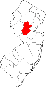 Map of New Jersey highlighting Somerset County | |
| Townships | ||
| CDPs | ||
| Other unincorporated communities | ||