Big Bass Lake, Pennsylvania
Big Bass Lake is a private community and census-designated place (CDP) in Clifton and Covington Townships in Lackawanna County and Lehigh Township, Wayne County, in Pennsylvania. The community's population was 1,270 at time of the 2010 United States Census.[1]
Big Bass Lake | |
|---|---|
 Big Bass Lake Location of Big Bass Lake  Big Bass Lake Big Bass Lake (the United States) | |
| Coordinates: 41°15′20″N 75°29′4″W | |
| Country | United States |
| State | Pennsylvania |
| County | Lackawanna Wayne |
| Township | Clifton Covington Lehigh |
| Area | |
| • Total | 4.37 sq mi (11.3 km2) |
| • Land | 4.13 sq mi (10.7 km2) |
| • Water | 0.24 sq mi (0.6 km2) |
| Elevation | 1,830 ft (560 m) |
| Population (2010) | |
| • Total | 1,270 |
| • Density | 290/sq mi (110/km2) |
| Time zone | UTC-5 (EST) |
| • Summer (DST) | UTC-4 (EDT) |
| Postal code | 18424 |
| Area code(s) | 570/272 |
| Website | Big Bass Lake Community Association |
Geography
Big Bass Lake is located at 41°15′20″N 75°29′4″W (41.2533624, -75.4840284).[2]
According to the United States Census Bureau, the CDP has a total area of 4.37 square miles, of which, 4.13 square miles of it is land and 0.24 square miles of it (5.49%) is water.
Climate
| Climate data for Big Bass Lake, Clifton Twp, Lackawanna County, Pennsylvania (1981 – 2010 averages). | |||||||||||||
|---|---|---|---|---|---|---|---|---|---|---|---|---|---|
| Month | Jan | Feb | Mar | Apr | May | Jun | Jul | Aug | Sep | Oct | Nov | Dec | Year |
| Average high °F (°C) | 30.9 (−0.6) |
34.5 (1.4) |
42.8 (6.0) |
55.3 (12.9) |
66.3 (19.1) |
74.4 (23.6) |
78.5 (25.8) |
77.1 (25.1) |
69.7 (20.9) |
58.1 (14.5) |
47.2 (8.4) |
35.3 (1.8) |
55.9 (13.3) |
| Average low °F (°C) | 13.9 (−10.1) |
16.1 (−8.8) |
22.6 (−5.2) |
33.4 (0.8) |
43.2 (6.2) |
51.9 (11.1) |
56.8 (13.8) |
55.6 (13.1) |
48.5 (9.2) |
37.2 (2.9) |
29.4 (−1.4) |
19.6 (−6.9) |
35.8 (2.1) |
| Average precipitation inches (mm) | 3.52 (89) |
3.00 (76) |
3.73 (95) |
4.33 (110) |
4.33 (110) |
4.73 (120) |
4.58 (116) |
3.91 (99) |
4.90 (124) |
4.67 (119) |
4.17 (106) |
3.77 (96) |
49.64 (1,260) |
| Average snowfall inches (cm) | 19.3 (49) |
13.9 (35) |
14.4 (37) |
3.4 (8.6) |
0.0 (0.0) |
0.0 (0.0) |
0.0 (0.0) |
0.0 (0.0) |
0.0 (0.0) |
0.1 (0.25) |
3.7 (9.4) |
11.6 (29) |
66.4 (169) |
| Source: PRISM[3] | |||||||||||||
Demographics
At the 2010 census, there were 1,270 people, 550 households, and 393 families in the CDP. The population density was 317.5 people per square mile. There were 1,211 housing units at an average density of 293.2/sq mi. The racial makeup of the CDP was 94.6% White, 2.3% African American, 0.9% Asian, 1.1% from other races, and 1.1% from two or more races. Hispanic or Latino of any race were 5% of the population.
There were 550 households, 14.4% had children under the age of 18 living with them, 59.8% were married couples living together, 7.3% had a female householder with no husband present, and 28.5% were non-families. 22.7% of households were made up of individuals, and 9.5% were one person aged 65 or older. The average household size was 2.31 and the average family size was 2.68.
The age distribution was 16.5% under the age of 18, 58.9% from 18 to 64, and 24.6% 65 or older. The median age was 51.7 years.
References
- "U.S. Census website". United States Census Bureau. Retrieved 2011-05-14.
- "US Gazetteer files: 2010, 2000, and 1990". United States Census Bureau. 2011-02-12. Retrieved 2011-04-23.
- "PRISM Climate Group, Oregon State U". www.prism.oregonstate.edu. Retrieved June 4, 2019.
External links
Municipalities and communities of Lackawanna County, Pennsylvania, United States | ||
|---|---|---|
| Cities | 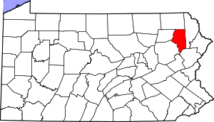 | |
| Boroughs | ||
| Townships | ||
| CDPs | ||
| Unincorporated communities | ||
Municipalities and communities of Wayne County, Pennsylvania, United States | ||
|---|---|---|
| Boroughs |  | |
| Townships | ||
| CDPs | ||
| Unincorporated communities | ||