Białystok County
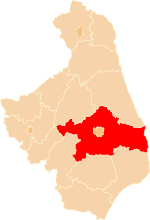
Białystok County (Polish: powiat białostocki) is a unit of territorial administration and local government (powiat) in Podlaskie Voivodeship, north-eastern Poland, on the border with Belarus. It was created on 1 January 1999 as a result of the Polish local government reforms passed in 1998. Its administrative seat is the city of Białystok, although the city is not part of the county (it constitutes a separate city county). [1]
Białystok County Powiat białostocki | |
|---|---|
 Flag  Coat of arms | |
 | |
| Coordinates (Białystok): 53°7′N 23°10′E | |
| Country | |
| Voivodeship | Podlaskie |
| Seat | Białystok |
| Gminas | |
| Area | |
| • Total | 2,984.64 km2 (1,152.38 sq mi) |
| Population (2006) | |
| • Total | 136,797 |
| • Density | 46/km2 (120/sq mi) |
| • Urban | 53,758 |
| • Rural | 83,039 |
| Car plates | BIA |
| Website | http://www.powiatbialostocki.pl/ |
The county contains nine towns: Łapy, 25 km (16 mi) south-west of Białystok, Czarna Białostocka, 22 km (14 mi) north of Białystok, Wasilków, 11 km (7 mi) north of Białystok, Choroszcz, 13 km (8 mi) west of Białystok, Supraśl, 16 km (10 mi) north-east of Białystok, Michałowo, 13 km (8 mi) east of Białystok, Zabłudów, 16 km (10 mi) south-east of Białystok, Tykocin, 29 km (18 mi) west of Białystok, and Suraż, 23 km (14 mi) south-west of Białystok.
The county covers an area of 2,984.64 square kilometres (1,152.4 sq mi), making it the largest county in Poland (ahead of Olsztyn County). As of 2006 its total population is 136,797, out of which the population of Łapy is 16,583, that of Czarna Białostocka is 9,596, that of Wasilków is 8,967, that of Choroszcz is 5,416, that of Supraśl is 4,578, that of Michałowo is 3,343, that of Zabłudów is 2,400, that of Tykocin is 1,893, that of Suraż is 982, and the rural population is 83,039. [2]
Neighbouring counties
Apart from the city of Białystok, Białystok County is bordered by Hajnówka County and Bielsk County to the south, Wysokie Mazowieckie County, Zambrów County and Łomża County to the west, Mońki County to the north-west, and Sokółka County to the north-east. It also borders Belarus to the east.
Administrative division
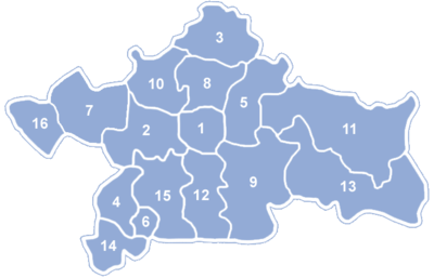
The county is subdivided into 15 gminas (nine urban-rural and six rural). These are listed in the following table, in descending order of population.
| Gmina | Type | Area (km2) |
Population (2006) |
Seat |
| Gmina Łapy | urban-rural | 127.6 | 23,132 | Łapy |
| Gmina Juchnowiec Kościelny | rural | 172.1 | 13,421 | Juchnowiec Kościelny |
| Gmina Choroszcz | urban-rural | 163.5 | 12,957 | Choroszcz |
| Gmina Wasilków | urban-rural | 127.2 | 12,790 | Wasilków |
| Gmina Supraśl | urban-rural | 188.0 | 12,780 | Supraśl |
| Gmina Czarna Białostocka | urban-rural | 206.5 | 11,692 | Czarna Białostocka |
| Gmina Zabłudów | urban-rural | 339.8 | 8,451 | Zabłudów |
| Gmina Dobrzyniewo Duże | rural | 160.7 | 7,933 | Dobrzyniewo Duże |
| Gmina Michałowo | urban-rural | 409.2 | 7,263 | Michałowo |
| Gmina Tykocin | urban-rural | 207.3 | 6,477 | Tykocin |
| Gmina Gródek | rural | 430.6 | 5,740 | Gródek |
| Gmina Turośń Kościelna | rural | 140.3 | 5,348 | Turośń Kościelna |
| Gmina Poświętne | rural | 114.3 | 3,761 | Poświętne |
| Gmina Zawady | rural | 112.7 | 3,014 | Zawady |
| Gmina Suraż | urban-rural | 76.6 | 2,038 | Suraż |
References
| Urban-rural gminas | | |
|---|---|---|
| Rural gminas | ||
| Seat (not part of the county) | ||
| City counties |  | |
|---|---|---|
| Land counties | ||
- "Wyniki badań bieżących - Baza Demografia - Główny Urząd Statystyczny". demografia.stat.gov.pl. Retrieved 2020-08-13.
- statlibr.stat.gov.pl http://statlibr.stat.gov.pl/F/?func=full-set-set&set_number=144744&set_entry=000012. Retrieved 2020-08-13. Missing or empty
|title=(help)