Bartow, West Virginia
Bartow is a census-designated place (CDP) in Pocahontas County, West Virginia, United States. The population was 111 at the 2010 census.[2]
Bartow, West Virginia | |
|---|---|
Census-designated place (CDP) | |
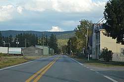 U.S. Route 250 | |
 Bartow, West Virginia | |
| Coordinates: 38°32′28″N 79°47′03″W | |
| Country | United States |
| State | West Virginia |
| County | Pocahontas |
| Area | |
| • Total | 0.464 sq mi (1.20 km2) |
| • Land | 0.464 sq mi (1.20 km2) |
| • Water | 0 sq mi (0 km2) |
| Elevation | 2,772 ft (845 m) |
| Population (2010)[2] | |
| • Total | 111 |
| • Density | 240/sq mi (92/km2) |
| Time zone | UTC-5 (Eastern (EST)) |
| • Summer (DST) | UTC-4 (EDT) |
| ZIP code | 24920 |
| Area code(s) | 304 & 681 |
| GNIS feature ID | 1550176[3] |
Bartow is situated along U.S. Route 250 and West Virginia Route 92 and on the East Fork Greenbrier River about 2 miles (3.2 km) east of Durbin. It has a post office with ZIP code 24920.[4]
Bartow is named for Col. Francis S. Bartow, a Confederate commander who died at the Battle of First Manassas on July 21, 1861.[5] The Battle of Greenbrier River, also known as the Battle of Camp Bartow, took place on October 3, 1861 about one mile (1.6 km) southeast of the present town.
The Camp Bartow Historic District was listed on the National Register of Historic Places in 1995.[6] Located near Bartow is the Camp Allegheny Historic District, listed in 1990.[6]
References
- "US Gazetteer files: 2010, 2000, and 1990". United States Census Bureau. 2011-02-12. Retrieved 2011-04-23.
- "U.S. Census website". United States Census Bureau. Retrieved 2011-05-14.
- U.S. Geological Survey Geographic Names Information System: Bartow, West Virginia
- ZIP Code Lookup Archived June 15, 2011, at the Wayback Machine
- Kenny, Hamill (1945). West Virginia Place Names: Their Origin and Meaning, Including the Nomenclature of the Streams and Mountains. Piedmont, WV: The Place Name Press. p. 97.
- "National Register Information System". National Register of Historic Places. National Park Service. July 9, 2010.
Municipalities and communities of Pocahontas County, West Virginia, United States | ||
|---|---|---|
| Towns |  Map of West Virginia highlighting Pocahontas County | |
| CDPs | ||
| Unincorporated communities |
| |
| Ghost towns | ||