Baixo Alentejo (intermunicipal community)
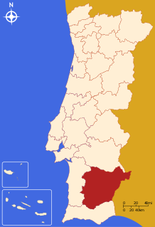
The Comunidade Intermunicipal do Baixo Alentejo (Portuguese pronunciation: [ˈbajʃu ɐlẽˈtɛʒu]; English: Lower Alentejo) is an administrative division in Portugal. It was created in 2009.[1] It is also a NUTS3 subregion of the Alentejo Region.[2] The seat of the intermunicipal community is Beja. Baixo Alentejo comprises 13 of the 14 municipalities of the Beja District. The population in 2011 was 126,692,[3] in an area of 8,542.72 km².[4]
Baixo Alentejo | |
|---|---|
 | |
| Coordinates: 38°01′N 7°52′W | |
| Country | |
| Region | Alentejo |
| Established | 2009 |
| Seat | Beja |
| Municipalities | 13 |
| Area | |
| • Total | 8,542.72 km2 (3,298.36 sq mi) |
| Population (2011) | |
| • Total | 126,692 |
| • Density | 15/km2 (38/sq mi) |
| Time zone | UTC±00:00 (WET) |
| • Summer (DST) | UTC+01:00 (WEST) |
| Website | cimbal |
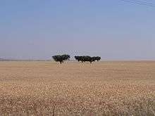
Fields of wheat in Baixo Alentejo
It is bordered on the North by Alentejo Central Subregion, on the East by Spain, on the South by the Algarve and on the West by Alentejo Litoral. It covers the Eastern part of the former Baixo Alentejo Province.
Municipalities
It is composed of 13 municipalities:[5]
| Municipality | Population (2011)[3] | Area (km²)[4] |
|---|---|---|
| Aljustrel | 9,257 | 458.47 |
| Almodôvar | 7,449 | 777.88 |
| Alvito | 2,504 | 264.85 |
| Barrancos | 1,834 | 168.42 |
| Beja | 35,854 | 1146.44 |
| Castro Verde | 7,276 | 569.44 |
| Cuba | 4,878 | 172.09 |
| Ferreira do Alentejo | 8,255 | 648.25 |
| Mértola | 7,274 | 1292.87 |
| Moura | 15,167 | 958.46 |
| Ourique | 5,389 | 663.31 |
| Serpa | 15,623 | 1105.63 |
| Vidigueira | 5,932 | 316.61 |
| Total | 126,692 | 8,542.72 |
References
- CIM Baixo Alentejo
- Adequação dos indicadores à nova organização territorial NUTS III / Entidades Intermunicipais, Instituto Nacional de Estatística, 18 March 2015
- Instituto Nacional de Estatística
- "Áreas das freguesias, concelhos, distritos e país". Archived from the original on 2018-11-05. Retrieved 2018-11-05.
- "Law nr. 75/2013" (PDF). Diário da República (in Portuguese). Assembly of the Republic (Portugal). Retrieved 18 August 2014.
External links
| Norte Region |
| ||||
|---|---|---|---|---|---|
| Centro Region |
| ||||
| Lisboa Region |
| ||||
| Alentejo Region |
| ||||
| Algarve Region |
| ||||
| Autonomous Regions | |||||
All these divisions are further subdivided into municipalities and parishes. | |||||
This article is issued from Wikipedia. The text is licensed under Creative Commons - Attribution - Sharealike. Additional terms may apply for the media files.