Azy-sur-Marne
Azy-sur-Marne is a commune in the department of Aisne in the Hauts-de-France region of northern France.
Azy-sur-Marne | |
|---|---|
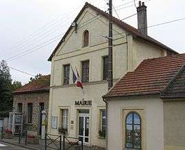 The Town Hall | |
Location of Azy-sur-Marne 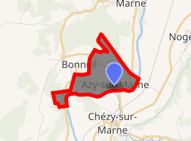
| |
 Azy-sur-Marne  Azy-sur-Marne | |
| Coordinates: 49°00′07″N 3°22′01″E | |
| Country | France |
| Region | Hauts-de-France |
| Department | Aisne |
| Arrondissement | Château-Thierry |
| Canton | Essômes-sur-Marne |
| Intercommunality | Région de Château-Thierry |
| Government | |
| • Mayor (2014-2020) | Jean-Pierre Lantoine |
| Area 1 | 2.78 km2 (1.07 sq mi) |
| Population (2017-01-01)[1] | 389 |
| • Density | 140/km2 (360/sq mi) |
| Time zone | UTC+01:00 (CET) |
| • Summer (DST) | UTC+02:00 (CEST) |
| INSEE/Postal code | 02042 /02400 |
| Elevation | 57–202 m (187–663 ft) (avg. 60 m or 200 ft) |
| 1 French Land Register data, which excludes lakes, ponds, glaciers > 1 km2 (0.386 sq mi or 247 acres) and river estuaries. | |
The inhabitants of the commune are known as Azyciens or Azyciennes[2]
Geography
Azy-sur-Marne is located 4 km south-west of Château-Thierry and 20 km east of Montreuil-aux-Lions. It can be accessed by the D969 road from Essômes-sur-Marne in the north through the village then west through the commune and continuing south to Romeny-sur-Marne. There is also a country road going west to Mont de Bonneil. The commune is almost entirely farmland with small forests in the north and west. The commune is within the Appellation d'origine contrôlée zone of Aisne Champagne.[3]
The southern border of the commune consists of the Marne river with no other identifiable watercourses in the commune.[3]
Neighbouring communes and villages[3]
Places adjacent to Azy-sur-Marne | ||||||||||
|---|---|---|---|---|---|---|---|---|---|---|
| ||||||||||
History
The village was severely damaged in the battles of the Marne in World War I.
Administration
List of Successive Mayors of Azy-sur-Marne[4]
| From | To | Name | Party | Position |
|---|---|---|---|---|
| 2001 | 2014 | Peter Pastorelli | DVG | |
| 2014 | Current | Jean-Pierre Lantoine |
(Not all data is known)
Population
| Year | Pop. | ±% |
|---|---|---|
| 2006 | 372 | — |
| 2007 | 374 | +0.5% |
| 2008 | 372 | −0.5% |
| 2009 | 379 | +1.9% |
| 2010 | 387 | +2.1% |
| 2011 | 396 | +2.3% |
| 2012 | 400 | +1.0% |
| 2013 | 408 | +2.0% |
| 2014 | 401 | −1.7% |
| 2015 | 396 | −1.2% |
| 2016 | 390 | −1.5% |
| 1793 | 1800 | 1806 | 1821 | 1831 | 1836 | 1841 | 1846 | 1851 |
|---|---|---|---|---|---|---|---|---|
| 253 | 266 | 276 | 246 | 259 | 265 | 254 | 245 | 251 |
| 1856 | 1861 | 1866 | 1872 | 1876 | 1881 | 1886 | 1891 | 1896 |
|---|---|---|---|---|---|---|---|---|
| 223 | 315 | 252 | 192 | 191 | 193 | 187 | 199 | 189 |
| 1901 | 1906 | 1911 | 1921 | 1926 | 1931 | 1936 | 1946 | 1954 |
|---|---|---|---|---|---|---|---|---|
| 194 | 176 | 168 | 160 | 181 | 195 | 167 | 167 | 173 |
| 1962 | 1968 | 1975 | 1982 | 1990 | 1999 | 2006 | 2010 | - |
|---|---|---|---|---|---|---|---|---|
| 200 | 222 | 286 | 326 | 372 | 381 | 372 | 387 | - |
Sites and Monuments
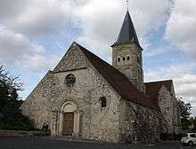
The commune has two sites that are registered as historical monuments:
- Other sites of interest
- the Mercier Vineyard for Moët & Chandon Champagne
See also
External links
- Azy-sur-Marne on the old National Geographic Institute website (in French)
- Bell Towers website (in French)
- Azy-sur-Marne on Lion1906
- Azy-sur-Marne on Géoportail, National Geographic Institute (IGN) website (in French)
- Azy on the 1750 Cassini Map
Notes and references
Notes
References
- "Populations légales 2017". INSEE. Retrieved 6 January 2020.
- Inhabitants of Aisne (in French)
- Google Maps
- List of Mayors of France (in French)
- Ministry of Culture, Mérimée PA00115515 Church of Saint Felix (in French)

- Ministry of Culture, Mérimée IA02001298 Chateau Park (in French)
| Wikimedia Commons has media related to Azy-sur-Marne. |