Axarquía
Axarquía (Spanish pronunciation: [axaɾˈki.a] (![]()
Axarquía | |
|---|---|
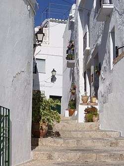 Street in Frigiliana. | |
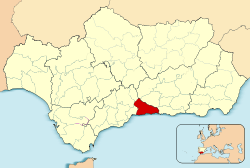 Location of Axarquía in Andalusia | |
| Country | |
| Autonomous community | |
| Province | Málaga |
| Area | |
| • Total | 1,023.6 km2 (395.2 sq mi) |
| Elevation | 2,066 m (6,778 ft) |
| Population (2018)[1] | |
| • Total | 211,328 |
| • Density | 210/km2 (530/sq mi) |
The comarca is composed of 31 municipalities, of which the capital is Vélez-Málaga. The Vélez, Algarrobo and Torrox rivers all run through the region. Its highest mountain is La Maroma, highest point of the Sierra de Tejeda, Penibaetic System.[3]
The Axarquía comarca is also known as Axarquía-Costa del Sol, for it includes the Costa del Sol Oriental sector of the Costa del Sol, east of Málaga city made up of Rincón de la Victoria, Vélez-Málaga, Algarrobo, Torrox and Nerja municipal terms.[4]
Etymology
The Dictionary of the Spanish Royal Academy defines the word "jarquía" (xarquía in old Castilian) as "district or territory located east of a great city and dependent on it" and says that it proceeds from Arabic شرقية Šarqiyya, meaning "eastern part" or " eastern." It coincides with the region of Axarquia which lies in the east of Málaga. The Royal Academy, in its spelling of the Spanish Language, 1999 edition, explains that, in old Castilian, consonant fricative phoneme ⟨x⟩ represented the palatal [ʃ] as in English sh sound, found in words like Axarquía, Don Quixote, Mexico, Texas etc.
Municipalities
| Municipality | Area (km²) | Population 2011[5] | Population 2018[6] |
|---|---|---|---|
| Alcaucín | 45.1 | 2,646 | 2,239 |
| Alfarnate | 34.0 | 1,295 | 1,105 |
| Alfarnatejo | 20.4 | 513 | 394 |
| Algarrobo | 9.7 | 6,229 | 6,367 |
| Almáchar | 14.4 | 1,892 | 1,802 |
| Árchez | 4.8 | 456 | 391 |
| Arenas | 26.3 | 1,339 | 1,177 |
| Benamargosa | 12.1 | 1,676 | 1,496 |
| Benamocarra | 5.7 | 3,066 | 2,999 |
| El Borge | 24.4 | 1,025 | 933 |
| Canillas de Aceituno | 42.0 | 1,873 | 1,620 |
| Canillas de Albaida | 33.2 | 900 | 732 |
| Colmenar | 66.0 | 3,560 | 3,392 |
| Comares | 25.5 | 1,508 | 1,323 |
| Cómpeta | 54.2 | 3,629 | 3,745 |
| Cútar | 19.4 | 641 | 614 |
| Frigiliana | 40.5 | 3,149 | 3,086 |
| Iznate | 7.5 | 924 | 863 |
| Macharaviaya | 7.2 | 496 | 442 |
| Moclinejo | 14.3 | 1,283 | 1,230 |
| Nerja | 85.1 | 21,086 | 21,061 |
| Periana | 58.8 | 3,502 | 3,068 |
| Rincón de la Victoria | 28.5 | 41,040 | 46,093 |
| Riogordo | 40.0 | 3,030 | 2,701 |
| Salares | 10.3 | 231 | 174 |
| Sayalonga | 18.3 | 1,477 | 1,658 |
| Sedella | 31.6 | 672 | 606 |
| Torrox | 50.0 | 16,387 | 16,465 |
| Totalán | 9.2 | 738 | 715 |
| Vélez-Málaga | 157.9 | 76,922 | 80,817 |
| Viñuela | 27.2 | 1,949 | 2,020 |
| Totals | 1,023.6 | 205,134 | 211,328 |
See also
References
- Estimate at 1 January 2018: Instituto Nacional de Estadística, Madrid.
- Rustical Travel, Holidays in Axarquia and Antequera on January 30, 2019
- Montañas de la Axarquía: Travesía Maroma-Lucero Archived December 13, 2009, at the Wayback Machine
- Fernando Almeida García & Damián López Cano, La Costa del Sol Oriental: un conflicto territorial entre el turismo, la agricultura y la urbanización metropolitana. Baética: Estudios de arte, geografía e historia, ISSN 0212-5099, Nº 25, 2003, pg. 67-80
- Census at 1 November 2011: Instituto Nacional de Estadística, Madrid.
- Estimate at 1 January 2018: Instituto Nacional de Estadística, Madrid.
External links
| Wikivoyage has a travel guide for Axarquía. |

- Tejeda (La Maroma), 2.068 m
- Axarquia Comarca Website