Arsure-Arsurette
Arsure-Arsurette is a commune in the Jura department in the region of Bourgogne-Franche-Comté in eastern France.
Arsure-Arsurette | |
|---|---|
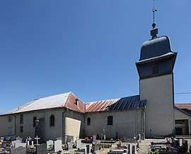 The church in Arsure-Arsurette | |
Location of Arsure-Arsurette 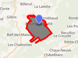
| |
 Arsure-Arsurette  Arsure-Arsurette | |
| Coordinates: 46°43′24″N 6°05′00″E | |
| Country | France |
| Region | Bourgogne-Franche-Comté |
| Department | Jura |
| Arrondissement | Lons-le-Saunier |
| Canton | Saint-Laurent-en-Grandvaux |
| Intercommunality | CC Plateau Nozeroy |
| Government | |
| • Mayor (2014-2020) | Catherine Rousset |
| Area 1 | 12.56 km2 (4.85 sq mi) |
| Population (2017-01-01)[1] | 101 |
| • Density | 8.0/km2 (21/sq mi) |
| Time zone | UTC+01:00 (CET) |
| • Summer (DST) | UTC+02:00 (CEST) |
| INSEE/Postal code | 39020 /39250 |
| Elevation | 875–1,205 m (2,871–3,953 ft) |
| 1 French Land Register data, which excludes lakes, ponds, glaciers > 1 km2 (0.386 sq mi or 247 acres) and river estuaries. | |
Population
| Year | Pop. | ±% |
|---|---|---|
| 1793 | 215 | — |
| 1800 | 224 | +4.2% |
| 1806 | 242 | +8.0% |
| 1821 | 498 | +105.8% |
| 1831 | 481 | −3.4% |
| 1836 | 500 | +4.0% |
| 1841 | 561 | +12.2% |
| 1846 | 553 | −1.4% |
| 1851 | 466 | −15.7% |
| 1856 | 436 | −6.4% |
| 1861 | 434 | −0.5% |
| 1866 | 411 | −5.3% |
| 1872 | 402 | −2.2% |
| 1876 | 384 | −4.5% |
| 1881 | 391 | +1.8% |
| 1886 | 370 | −5.4% |
| 1891 | 340 | −8.1% |
| 1896 | 325 | −4.4% |
| 1901 | 299 | −8.0% |
| 1906 | 288 | −3.7% |
| 1911 | 301 | +4.5% |
| 1921 | 242 | −19.6% |
| 1926 | 229 | −5.4% |
| 1931 | 231 | +0.9% |
| 1936 | 217 | −6.1% |
| 1946 | 213 | −1.8% |
| 1954 | 198 | −7.0% |
| 1962 | 169 | −14.6% |
| 1968 | 148 | −12.4% |
| 1975 | 127 | −14.2% |
| 1982 | 110 | −13.4% |
| 1990 | 99 | −10.0% |
| 1999 | 87 | −12.1% |
| 2008 | 90 | +3.4% |
| 2015 | 99 | +10.0% |
See also
References
- "Populations légales 2017". INSEE. Retrieved 6 January 2020.
-

| Wikimedia Commons has media related to Arsure-Arsurette. |
| Authority control |
|
|---|
This article is issued from Wikipedia. The text is licensed under Creative Commons - Attribution - Sharealike. Additional terms may apply for the media files.