Arrondissement of Draguignan
The arrondissement of Draguignan (French pronunciation: [dʁaɡiɲɑ̃]) is an arrondissement of France in the Var department in the Provence-Alpes-Côte d'Azur region. It has 54 communes.[1] Its population is 306,320 (2016), and its area is 2,220.8 km2 (857.5 sq mi).[2]
Draguignan | |
|---|---|
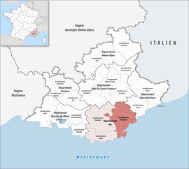 Location within the region Provence-Alpes-Côte d'Azur | |
| Country | France |
| Region | Provence-Alpes-Côte d'Azur |
| Department | Var |
| No. of communes | 54 |
| Subprefecture | Draguignan |
| Area | |
| • Total | 2,220.8 km2 (857.5 sq mi) |
| Population (2016) | |
| • Total | 306,320 |
| • Density | 138/km2 (360/sq mi) |
| INSEE code | 831 |
Composition
The communes of the arrondissement of Draguignan, and their INSEE codes, are:[1]
- Les Adrets-de-l'Estérel (83001)
- Ampus (83003)
- Les Arcs (83004)
- Bagnols-en-Forêt (83008)
- Bargème (83010)
- Bargemon (83011)
- La Bastide (83013)
- Le Bourguet (83020)
- Brenon (83022)
- Callas (83028)
- Callian (83029)
- Cavalaire-sur-Mer (83036)
- Châteaudouble (83038)
- Châteauvieux (83040)
- Claviers (83041)
- Cogolin (83042)
- Comps-sur-Artuby (83044)
- La Croix-Valmer (83048)
- Draguignan (83050)
- Fayence (83055)
- Figanières (83056)
- Flayosc (83058)
- Fréjus (83061)
- La Garde-Freinet (83063)
- Gassin (83065)
- Grimaud (83068)
- Lorgues (83072)
- La Martre (83074)
- La Môle (83079)
- Mons (83080)
- Montauroux (83081)
- Montferrat (83082)
- La Motte (83085)
- Le Muy (83086)
- Le Plan-de-la-Tour (83094)
- Puget-sur-Argens (83099)
- Ramatuelle (83101)
- Rayol-Canadel-sur-Mer (83152)
- Roquebrune-sur-Argens (83107)
- La Roque-Esclapon (83109)
- Saint-Antonin-du-Var (83154)
- Sainte-Maxime (83115)
- Saint-Paul-en-Forêt (83117)
- Saint-Raphaël (83118)
- Saint-Tropez (83119)
- Salernes (83121)
- Seillans (83124)
- Sillans-la-Cascade (83128)
- Tanneron (83133)
- Taradeau (83134)
- Tourrettes (83138)
- Trans-en-Provence (83141)
- Trigance (83142)
- Vidauban (83148)
History
The arrondissement of Draguignan was created in 1800.[3] At the January 2017 reorganisation of the arrondissements of Var, it received two communes from the arrondissement of Brignoles, and it lost six communes to the arrondissement of Brignoles.[4]
As a result of the reorganisation of the cantons of France which came into effect in 2015, the borders of the cantons are no longer related to the borders of the arrondissements. The cantons of the arrondissement of Draguignan were, as of January 2015:[5]
- Callas
- Comps-sur-Artuby
- Draguignan
- Fayence
- Fréjus
- Grimaud
- Lorgues
- Le Luc
- Le Muy
- Saint-Raphaël
- Saint-Tropez
- Salernes
References
- "Arrondissement de Draguignan (831)". INSEE. Retrieved 2019-10-04.
- "Comparateur de territoire, géographie au 01/01/2019". INSEE. Retrieved 2019-10-04.
- Historique du Var
- "Arrêté préfectoral, 20 December 2016" (PDF). pp. 17–21. Retrieved 2019-10-27.
- "Populations légales 2012" (PDF). INSEE. December 2014. Retrieved 2019-10-07.