Arkansas Highway 43
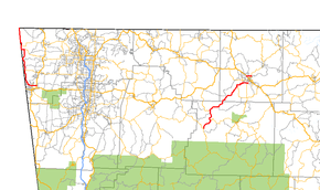
Highway 43 (AR 43, Ark. 43, and Hwy. 43) is a designation for three north–south state highways in northwest Arkansas. One segment of 27.1 miles (43.6 km) runs from Highway 59 in Siloam Springs north into Delaware County, Oklahoma[2] along Oklahoma State Highway 20 (SH-20) to terminate at Missouri Route 43 (Route 43) at the Missouri/Oklahoma/Arkansas tri-point near Southwest City, Missouri.[3] A second segment of 20.0 miles (32.2 km) runs northeast from Highway 21 at Boxley to Highway 7 in Harrison.[4][5] The third segment runs 1.8 miles (2.9 km) north in Harrison from US Route 65 (US 65) to Highway 7 .[5]
| ||||
|---|---|---|---|---|
 | ||||
| Route information | ||||
| Maintained by ArDOT | ||||
| Section 1 | ||||
| Length | 27.1 mi[1] (43.6 km) | |||
| South end | ||||
| North end | ||||
| Section 2 | ||||
| Length | 30.0 mi[1] (48.3 km) | |||
| South end | ||||
| North end | ||||
| Section 3 | ||||
| Length | 1.8 mi[1] (2.9 km) | |||
| South end | ||||
| North end | ||||
| Highway system | ||||
| ||||

Route description
Siloam Springs to Oklahoma
The route begins at AR 264 in Siloam Springs and runs west before turning north and running close to the Oklahoma state line. AR 43 runs through Cherokee City before meeting AR 102 and later AR 72 in Maysville.
After Maysville, AR 43 runs along the Oklahoma state line concurrent with Oklahoma State Highway 20. This continues for approximately 5.4 miles (8.7 km) until both routes terminate at Missouri Route 43.
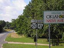
For the northernmost few miles of the overlapping stretch of road AR 43/SH 20 turns toward the west, no longer straddling the state line. For those few miles, Highway 43 is located wholly within the state of Oklahoma but is not apparent to the traveler.[3]
Boxley to Harrison
AR 43 begins at Highway 21 at Boxley, and runs north near the Buffalo National River. The route enters Boone County and serves as the western terminus of AR 206, and the southern terminus of AR 397. AR 43 terminates at AR 7 in south Harrison. The route runs for 15.9 miles (25.6 km) in Newton County and 14.1 miles (22.7 km) in Boone County.
Harrison
The route begins at U.S. Route 65 on the north end of Harrison and runs east to AR 7 north of Harrison.
History

Originally numbered AR 99, the route was renumbered in the mid-1960s to its present number. AR 99's southern terminus was originally at U.S. Route 412 in Siloam Springs, but was rerouted in the mid-1990s along the former AR 204, terminating at Highway 59.[6]
Major intersections
Western section
| County | Location | mi | km | Destinations | Notes |
|---|---|---|---|---|---|
| Benton | Siloam Springs | Southern terminus of western section | |||
| Country Club Road | Interchange via connector road | ||||
| | |||||
| | |||||
| Maysville | |||||
| Arkansas–Oklahoma line | South end of SH-20 overlap | ||||
| Arkansas–Missouri line | North end of SH-20 overlap Continuation into Missouri | ||||
1.000 mi = 1.609 km; 1.000 km = 0.621 mi
| |||||
Eastern sections
| County | Location | mi | km | Destinations | Notes | ||
|---|---|---|---|---|---|---|---|
| Newton | Boxley | ||||||
| | |||||||
| | |||||||
| Boone | | ||||||
| | |||||||
| Harrison | |||||||
| Gap in route | |||||||
| 1.000 mi = 1.609 km; 1.000 km = 0.621 mi | |||||||
Siloam Springs spur
| |
|---|---|
| Location | Siloam Springs |
| Length | 1.0 mi (1.6 km) |
Arkansas Highway 43 Spur was a spur route of 1.0 mile (1.6 km) in Siloam Springs.[6] It was decommissioned when AR 43 was rerouted along AR 204.
See also


- List of state highways in Arkansas
References
- Planning and Research Division (2010). "Arkansas Road Log Database". Arkansas State Highway and Transportation Department. Archived from the original (Database) on 23 June 2011. Retrieved June 9, 2011.
- Delaware County, Oklahoma (PDF) (Map). Oklahoma Department of Transportation. June 2004. Retrieved January 30, 2013.
- General Highway Map, Benton County, Arkansas (PDF) (Map). 1:62500. Cartography by Planning and Research Division. Arkansas State Highway and Transportation Department. August 20, 2012. Retrieved January 30, 2013.
- General Highway Map, Newton County, Arkansas (PDF) (Map). 1:62500. Cartography by Planning and Research Division. Arkansas State Highway and Transportation Department. September 16, 1996. Archived from the original (PDF) on September 29, 2011. Retrieved January 30, 2013.
- General Highway Map, Boone County, Arkansas (PDF) (Map). 1:62500. Cartography by Planning and Research Division. Arkansas State Highway and Transportation Department. December 22, 2011. Retrieved January 30, 2013.
- "Benton County, Arkansas." Arkansas State Highway and Transportation Department. AHTD Benton County map, 1987. Retrieved on June 29, 2010.
External links

- AR-43 at Roadklahoma