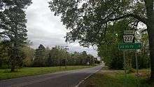
Arkansas Highway 227
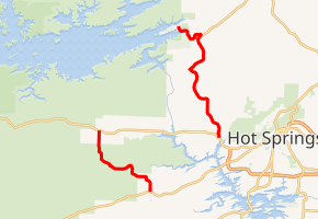
Highway 227 (AR 227, Ark. 227, and Hwy. 227) is a designation for two north–south state highways in Garland County, Arkansas. One segment of 7.43 miles (11.96 km) runs north from US Highway 70 (US 70) to US 270.[3] A second route of 11.74 miles (18.89 km) begins at US 270 at Piney and runs north to Lake Ouachita State Park. Both routes are maintained by the Arkansas Department of Transportation (ARDOT).[2]
| ||||
|---|---|---|---|---|
| ||||
| Route information | ||||
| Maintained by ArDOT | ||||
| Existed | July 10, 1957[1]–present | |||
| Section 1 | ||||
| Length | 7.43 mi[2] (11.96 km) | |||
| South end | ||||
| North end | ||||
| Section 2 | ||||
| Length | 11.74 mi[2] (18.89 km) | |||
| South end | ||||
| North end | Lake Ouachita State Park | |||
| Location | ||||
| Counties | Garland | |||
| Highway system | ||||
| ||||

Route description
US 70 to US 270
Highway 227 begins at US 70 west of Hot Springs. The highway winds north through rolling hills through the community of Sunshine before terminating at US 270 west of Royal.
Piney to Lake Ouachita State Park
Highway 227 begins at US 270 west of Hot Springs at Piney near Lake Hamilton. The route runs north through Hawes and Mountain Pine before intersecting with Highway 192. Following this intersection, the route enters the Ouachita National Forest and Lake Ouachita State Park. The highway terminates at Crawdad Island Rd/Mountain Pine Rd (state park roads) near the visitor's center.
History
Highway 227 was created from US 270 to Lake Ouachita State Park by the Arkansas State Highway Commission (ASHC) on July 10, 1957.[1] The second segment was created on July 28, 1965.[4]
Major intersections
The entire route is in Garland County.
| Location | mi[2] | km | Destinations | Notes | |||
|---|---|---|---|---|---|---|---|
| | 0.00 | 0.00 | Southern terminus | ||||
| | 7.43 | 11.96 | Northern terminus | ||||
| Gap in route | |||||||
| Piney | 0.00 | 0.00 | Southern terminus | ||||
| | 9.20 | 14.81 | Hwy. 192 western terminus | ||||
| Lake Ouachita State Park | 11.74 | 18.89 | Northern terminus | ||||
| 1.000 mi = 1.609 km; 1.000 km = 0.621 mi | |||||||
See also


References
- Arkansas State Highway Commission (1969). "Minutes of the Meeting of the Arkansas State Highway Commission" (PDF). Little Rock: Arkansas State Highway Commission. p. 1784. OCLC 21798861. Retrieved November 21, 2018.CS1 maint: ref=harv (link)
- System Information and Research Division (2014). "Arkansas Road Log Database" (MDB). Arkansas State Highway and Transportation Department. Retrieved March 27, 2016.
- General Highway Map, Garland County, Arkansas (PDF) (Map). Cartography by Planning and Research Division. Arkansas State Highway and Transportation Department. February 17, 2015. Retrieved April 19, 2016.
- Arkansas State Highway Commission (1979), p. 692.