Arkansas Highway 187
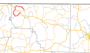
Arkansas Highway 187 (AR 187 and Hwy. 187) is a roughly three–quarter loop state highway in Carroll County, Arkansas. The route of 16.57 miles (26.67 km) runs from Highway 23 to US Highway 62.[2] The highway passes over the Beaver Bridge, a 1943 suspension bridge, and Beaver Dam, constructed in the 1960s to provide water and electricity for the Northwest Arkansas region.
| ||||
|---|---|---|---|---|
 | ||||
| Route information | ||||
| Maintained by ArDOT | ||||
| Length | 16.57 mi[1] (26.67 km) | |||
| Major junctions | ||||
| From | ||||
| To | ||||
| Location | ||||
| Counties | Carroll | |||
| Highway system | ||||
| ||||

An earlier highway, also called Arkansas Highway 187, existed in Tuckerman from AR 37 north and east back to US 67 (now AR 367) from 1945 until 1953.[3][4][5][6]
Route description
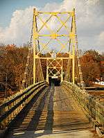
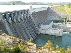
The route begins at Highway 23 north of Eureka Springs and runs northwest over the Beaver Bridge to enter Beaver. The bridge is restricted to one–lane traffic with a 20,000 pounds (9,100 kg) weight limit and is listed on the National Register of Historic Places.[1] After Beaver, Highway 187 curves east to meet US 62. The routes form a 0.9 miles (1.4 km) concurrency through Busch, after which Highway 187 turns south. Highway 187 enters Beaver Dam Park and rides atop Beaver Dam for 0.25 miles (0.40 km).[1]
The route continues along Beaver Lake before turning east to terminate at US 62 near Eureka Springs.
Major intersections
Mile markers reset at concurrencies. The entire route is in Carroll County.
| Location | mi[1] | km | Destinations | Notes | |
|---|---|---|---|---|---|
| | 0.00 | 0.00 | |||
| Table Rock Lake | 4.57– 4.68 | 7.35– 7.53 | Beaver Bridge | ||
| Busch | 7.32 | 11.78 | |||
| 0.00 | 0.00 | ||||
| Beaver Lake | 13.59– 13.84 | 21.87– 22.27 | Beaver Dam | ||
| | 16.57 | 26.67 | |||
| 1.000 mi = 1.609 km; 1.000 km = 0.621 mi | |||||
References
- Planning and Research Division (2010). "Arkansas Road Log Database". Arkansas State Highway and Transportation Department. Archived from the original (Database) on 23 June 2011. Retrieved June 9, 2011.
- General Highway Map (PDF) (Map) (Carroll County ed.). Arkansas State Highway and Transportation Department. Retrieved June 27, 2011.
- https://www.arkansashighways.com/Trans_Plan_Policy/mapping_graphics/archived_tourist_maps/1942.TIF. Missing or empty
|title=(help) - "1945 Arkansas state highway map".
- https://www.arkansashighways.com/Trans_Plan_Policy/mapping_graphics/archived_tourist_maps/1952A.TIF. Missing or empty
|title=(help) - https://www.arkansashighways.com/Trans_Plan_Policy/mapping_graphics/archived_tourist_maps/1953.TIF. Missing or empty
|title=(help)