Antero Soriano Highway
The Antero Soriano Highway, also known as Centennial Road and EPZA Diversion Road, is a two-to-six lane, 21.6-kilometer (13.4 mi) highway traversing through the western coast of Cavite.[1][2][3] It is one of the three major highways located in the province, the others are Aguinaldo Highway and Governor's Drive.
| |
|---|---|
| Centennial Road EPZA Diversion Road | |
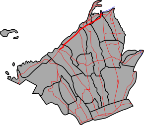 Route alignment of Antero Soriano Highway | |
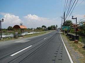 Antero Soriano Highway in Noveleta | |
| Route information | |
| Maintained by Department of Public Works and Highways (DPWH) - Cavite 1st District Engineering Office and Cavite 2nd District Engineering Office | |
| Length | 21.6 km (13.4 mi) |
| Component highways | |
| Major junctions | |
| Northeast end | |
| Southwest end | |
| Location | |
| Provinces | Cavite |
| Major cities | Imus, General Trias |
| Towns | Kawit, Noveleta, Rosario, Tanza, Naic |
| Highway system | |
| |
.svg.png)
.svg.png)

The northeastern terminus of the highway is at Kawit then travels along the cities of Imus, and General Trias, municipalities of Noveleta, Tanza and ends at the municipality of Naic.
The highway is designated as a component part of the National Route 64 (N64) and National Route 402 (N402) of the Philippine highway network.
The highway was named after Antero Soriano, the country's former senator and former governor of Cavite.[4]
Intersections
The entire route is located in Cavite. Intersections are numbered by kilometer post, with Rizal Park in Manila designated as kilometer 0.
| City/Municipality | km | mi | Destinations | Notes | |
|---|---|---|---|---|---|
| Kawit | 21.335 | 13.257 | Northern terminus. Access to | ||
| 21.766 | 13.525 | Kanluran Bridge | |||
| 22.000 | 13.670 | Route 64 reassurance sign. | |||
| 22.143 | 13.759 | Pag-asa Bridge | |||
| Kawit–Imus boundary | 22.528 | 13.998 | Gahak Bridge | ||
| Kawit | 24.280 | 15.087 | Batong Dalig Bridge | ||
| Kawit–Noveleta boundary | |||||
| Noveleta–General Trias boundary | 27.061 | 16.815 | Ilang-Ilang Bridge I | ||
| General Trias | 27.110 | 16.845 | Ilang-Ilang Bridge II | ||
| Kilometer number reverses. | |||||
| General Trias–Tanza boundary | 32.367 | 20.112 | Tejero Bridge | ||
| Tanza | |||||
| 32.721 | 20.332 | Biwas Bridge | |||
| 34.000 | 21.127 | Tanza kilometer zero. Route 64 reassurance sign. | |||
| Kilometer number reverses. Route number changes from N64 to N401 towards Naic. | |||||
| 37.286 | 23.168 | Obispo Bridge | |||
| 39.721 | 24.681 | Calibuyo Bridge | |||
| Tanza–Naic boundary | 43.452 | 27.000 | Timalan bridge. Cavite 1st District Engineering Office–Cavite 2nd District Engineering Office highway boundary. | ||
| Naic | 43.180 | 26.831 | Bisaya Bridge | ||
| 43.395 | 26.964 | Palanas Bridge | |||
| 46.000 | 28.583 | Naic kilometer zero. | |||
| Traffic light Intersection. Continuation south as Governor's Drive towards Maragondon and Ternate. | |||||
1.000 mi = 1.609 km; 1.000 km = 0.621 mi
| |||||
References
- "Cavite". www.dpwh.gov.ph. Archived from the original on 2018-01-09. Retrieved 2018-08-19.
- "Cavite 2nd". www.dpwh.gov.ph. Archived from the original on 2018-10-01. Retrieved 2018-08-19.
- "Cavite Sub". www.dpwh.gov.ph. Archived from the original on 2018-10-02. Retrieved 2018-08-19.
- panonad. "Republic Act No. 5782". laws.chanrobles.com. Retrieved 2018-08-19.
External links
| Wikimedia Commons has media related to Antero Soriano Highway. |
| Expressways |
| ||||||||
|---|---|---|---|---|---|---|---|---|---|
| National roads |
| ||||||||
| Arterial Routes |
| ||||||||