Altamont, Tennessee
Altamont is a town in Grundy County, Tennessee, United States. The population was 1,045 at the 2010 census.[6] It is the county seat of Grundy County.[7]
Altamont, Tennessee | |
|---|---|
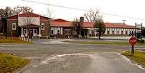
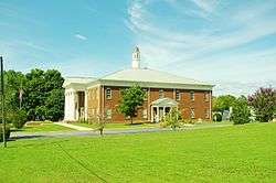 Grundy County Courthouse in Altamont | |
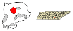 Location of Altamont in Grundy County, Tennessee. | |
| Coordinates: 35°26′2″N 85°43′57″W | |
| Country | United States |
| State | Tennessee |
| County | Grundy |
| Established | 1848 |
| Incorporated | 1854[1] |
| Named for | Fusion of alto ("altitude") and mont ("mountain") |
| Area | |
| • Total | 20.59 sq mi (53.34 km2) |
| • Land | 20.59 sq mi (53.34 km2) |
| • Water | 0.00 sq mi (0.00 km2) |
| Elevation | 1,854 ft (565 m) |
| Population (2010) | |
| • Total | 1,045 |
| • Estimate (2019)[3] | 1,067 |
| • Density | 51.81/sq mi (20.01/km2) |
| Time zone | UTC-6 (Central (CST)) |
| • Summer (DST) | UTC-5 (CDT) |
| ZIP code | 37301 |
| Area code(s) | 931 |
| FIPS code | 47-00940[4] |
| GNIS feature ID | 1275640[5] |
History
Altamont was established in 1848 as a county seat for Grundy County, which had been created in 1844. Adrian Northcut, a prominent local farmer and military officer, was the prime advocate for the site's selection.[8] The town's name comes from combining alto (meaning "altitude") and mont (meaning "mountain").[9] Although the Civil War somewhat stunted the town's growth, by 1870 Altamont's population had grown to 217.[10]
Altamont has one of the oldest Mormon congregations in the southeastern United States. The congregation was formed in the 1890s, and a Mormon chapel was built in Northcutt Cove just north of Altamont in 1909. Shortly thereafter, several members of the congregation migrated to Altamont. A Mormon chapel was completed along Main Street in 1947, and a newer chapel was completed just off Viola Road in 1981.[11]
In 1988, Altamont's school building was renovated and now houses the Altamont City Hall and the Altamont Library and Museum. The building was renamed the "Florence R. Scruggs Municipal Building" in 1996, after a long-time teacher at the school.[12]
Geography
Altamont is located in north-central Grundy County at 35°26′2″N 85°43′57″W (35.433954, -85.732428).[13] It is situated atop the southern Cumberland Plateau between the plateau's Highland Rim escarpment to the west and Savage Gulf to the east. The latter is a gorge sliced by the upper watershed of the Collins River (Altamont is part of this watershed) as the river descends from the plateau to the Highland Rim en route to its mouth at the Caney Fork in adjacent Warren County. Altamont is surrounded by hills on all sides, and the central area of the town itself straddles a flattened-out hillslope.
Several state highways intersect at the center of Altamont. Tennessee State Route 56 (Main Street) connects Altamont to Beersheba Springs and McMinnville to the north and Coalmont, Tracy City and Monteagle to the south. Tennessee State Route 108, connects the town to Viola and McMinnville to the northwest and Whitwell to the southeast. Tennessee State Route 50 connects Altamont to Pelham and Interstate 24 to the southwest.
According to the United States Census Bureau, the town has a total area of 20.2 square miles (52.2 km2), all land.[14]
Demographics
| Historical population | |||
|---|---|---|---|
| Census | Pop. | %± | |
| 1880 | 110 | — | |
| 1890 | 67 | −39.1% | |
| 1920 | 114 | — | |
| 1930 | 140 | 22.8% | |
| 1940 | 238 | 70.0% | |
| 1950 | 296 | 24.4% | |
| 1960 | 552 | 86.5% | |
| 1970 | 546 | −1.1% | |
| 1980 | 679 | 24.4% | |
| 1990 | 679 | 0.0% | |
| 2000 | 1,136 | 67.3% | |
| 2010 | 1,045 | −8.0% | |
| Est. 2019 | 1,067 | [3] | 2.1% |
| Sources:[15][16] | |||
As of the census[4] of 2000, there were 1,136 people, 400 households, and 309 families residing in the town. The population density was 51.5 people per square mile (19.9/km2). There were 438 housing units at an average density of 19.9 per square mile (7.7/km2). The racial makeup of the town was 97.89% White, 0.09% African American, 0.53% Native American, 0.09% Asian, 0.88% from other races, and 0.53% from two or more races. Hispanic or Latino of any race were 2.02% of the population.
There were 400 households, out of which 38.3% had children under the age of 18 living with them, 62.3% were married couples living together, 10.0% had a female householder with no husband present, and 22.8% were non-families. 20.0% of all households were made up of individuals, and 5.8% had someone living alone who was 65 years of age or older. The average household size was 2.76 and the average family size was 3.15.
In the town, the population was spread out, with 27.3% under the age of 18, 9.3% from 18 to 24, 30.1% from 25 to 44, 22.1% from 45 to 64, and 11.2% who were 65 years of age or older. The median age was 33 years. For every 100 females, there were 108.8 males. For every 100 females age 18 and over, there were 113.4 males.
The median income for a household in the town was $21,767, and the median income for a family was $25,000. Males had a median income of $26,944 versus $15,000 for females. The per capita income for the town was $10,074. About 28.9% of families and 32.1% of the population were below the poverty line, including 34.4% of those under age 18 and 32.4% of those age 65 or over.
Notable people
- Arlo Gilliam, singer-songwriter
References
- Tennessee Blue Book, 2005-2006, pp. 618-625.
- "2019 U.S. Gazetteer Files". United States Census Bureau. Retrieved July 30, 2020.
- "Population and Housing Unit Estimates". United States Census Bureau. May 24, 2020. Retrieved May 27, 2020.
- "U.S. Census website". United States Census Bureau. Retrieved 2008-01-31.
- "US Board on Geographic Names". United States Geological Survey. 2007-10-25. Retrieved 2008-01-31.
- Tennessee Department of Economic and Community Development, Certified Population of Tennessee Incorporated Municipalities and Counties Archived 2014-06-30 at the Wayback Machine, State of Tennessee official website, 14 July 2011. Retrieved: 6 December 2013.
- "Find a County". National Association of Counties. Archived from the original on 2011-05-31. Retrieved 2011-06-07.
- Charles Sherrill, "Grundy County in 1850 Archived 2011-07-26 at the Wayback Machine." The Pathfinder vol. II, no. 2 (1997), 3. Warning: Large .pdf file.
- William Ray Turner, Mona G. Moreland (ed.), "Odds and Ends Archived 2011-07-26 at the Wayback Machine." The Pathfinder vol. VII, no. 3 (2002), 1. Warning: Large .pdf file.
- Charles Sherrill, "Grundy County in 1870 Archived 2011-07-26 at the Wayback Machine." The Pathfinder vol. II, no. 4 (1997), 21.
- Mary Tate Brooks, "The Church of Jesus Christ of Latter-day Saints of Altamont, Tennessee Archived 2011-07-26 at the Wayback Machine." The Pathfinder vol. II, no. 3 (1997), 7-9. Warning: Large .pdf file.
- Mary Tate Brooks, "Women of Grundy County: Florence Rolling Scruggs Archived 2011-07-26 at the Wayback Machine." The Pathfinder vol. I, no. 3 (1996), 8. Warning: Large .pdf file.
- "US Gazetteer files: 2010, 2000, and 1990". United States Census Bureau. 2011-02-12. Retrieved 2011-04-23.
- "Geographic Identifiers: 2010 Demographic Profile Data (G001): Altamont town, Tennessee". American Factfinder. U.S. Census Bureau. Retrieved February 24, 2017.
- "Census of Population and Housing: Decennial Censuses". United States Census Bureau. Retrieved 2012-03-04.
- "Incorporated Places and Minor Civil Divisions Datasets: Subcounty Resident Population Estimates: April 1, 2010 to July 1, 2012". Population Estimates. U.S. Census Bureau. Archived from the original on 11 June 2013. Retrieved 11 December 2013.
External links
| Wikimedia Commons has media related to Altamont, Tennessee. |
Municipalities and communities of Grundy County, Tennessee, United States | ||
|---|---|---|
| Cities | ||
| Towns | ||
| CDP | ||
| Footnotes | ‡This populated place also has portions in an adjacent county or counties | |