Aktobe Region
Aktobe Region (Kazakh: Ақтөбе облысы, romanized: Aqtóbe oblysy; Russian: Актюбинская область, romanized: Aktyubinskaya oblast) is a region of Kazakhstan. The Aktobe regional capital is the city of Aktobe, with a population of more than 340,000. The region itself has a population 867,828. The name "Aktobe" comes from Kazakh "Ақ" (white) and "төбе" (hill); supposedly, Aktobe's initial settlers were able to see white mountains far to the north.
Aktobe Region Ақтөбе облысы Актюбинская область | |
|---|---|
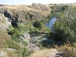 Nature in Aktobe Region | |
 Coat of arms | |
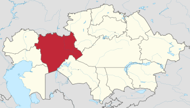 Map of Kazakhstan, location of Aktobe Province highlighted | |
| Coordinates: 50°17′N 57°10′E | |
| Country | Kazakhstan |
| Capital | Aktobe |
| Government | |
| • Akim | Ondasyn Urazalin |
| Area | |
| • Total | 300,629 km2 (116,074 sq mi) |
| Population (2013-02-01)[1] | |
| • Total | 797,036 |
| • Density | 2.7/km2 (6.9/sq mi) |
| Time zone | UTC+5 (West) |
| • Summer (DST) | UTC+5 (not observed) |
| Postal codes | 030000 |
| Area codes | +7 (713) |
| ISO 3166 code | KZ-AKT |
| Vehicle registration | 04, D |
| Districts | 12 |
| Cities | 8 |
| Villages | 441 [2] |
| Website | http://aktobe.gov.kz |
Geography
The area of the region is 300,600 square kilometers, making it the second largest region of Kazakhstan, after Karaganda Region. Aktobe Region borders Russia (Orenburg Oblast) to the north and Uzbekistan (Karakalpakstan) to the south, and also borders six other Kazakh regions: the Atyrau Region to the west, the Mangystau Region to the south-west, the Karaganda Region to the east, the Kostanay Region to the north-east, the Kyzylorda Region to the south-east, and the West Kazakhstan Region to the north-west. The Ilek River, a tributary of the Ural River, flows through the region.
Administrative divisions
The region is administratively divided into twelve districts and the city of Aktobe.[5]
- Alga District, with the administrative center in the town of Alga;
- Ayteke Bi District, the selo of Komsomol;
- Bayganin District, the selo of Karauilkeldy;
- Kargaly District, the settlement of Badamsha;
- Khromtau District, the town of Khromtau;
- Kobda District, the aul of Kobda;
- Martuk District, the selo of Martuk;
- Mugalzhar District, the town of Kandyagash;
- Oiyl District, the selo of Oiyl;
- Shalkar District, the town of Shalkar;
- Temir District, the town of Temir;
- Yrgyz District, the selo of Yrgyz.
* Eight localities in Aktobe Region have town status. These are Aktobe, Alga, Embi, Kandyagash, Khromtau, Shalkar, Temir, and Zhem.
* Two more localities - Shubarkuduk and Shubarshi - have status of urban-type settlement.[6][7]
See also
- Aral Sea
- Mugodzhar Hills
- Southern Ural Mountains
References
- Agency of statistics of the Republic of Kazakhstan: Численность населения Республики Казахстан по областям с начала 2013 года до 1 февраля 2013 года (russisch; Excel-Datei; 55 kB).
- Official site - General Information Archived 2007-10-10 at the Wayback Machine
- "Численность населения Республики Казахстан по отдельным этносам на начало 2020 года". Stat.kz. Retrieved 2020-08-03.
- "Численность населения Республики Казахстан по отдельным этносам на начало 2020 года". Stat.kz. Retrieved 2020-08-03.
- Выбор района (in Russian). Департамент статистики Актюбинской области. Archived from the original on 19 December 2014. Retrieved 1 June 2012.
- Население Республики Казахстан (PDF) (in Russian). Департамент социальной и демографической статистики. Archived from the original (PDF) on 16 June 2012. Retrieved 2 June 2012.
- Осадчий, Uеоргий (March 10, 2011). Город: сила притяжения (in Russian). Актюбинский вестник. Archived from the original on 25 June 2015. Retrieved 2 June 2012.
External links
- Official Site (in Kazakh and Russian)
| Wikimedia Commons has media related to Aqtöbe Province (Aktobe Region). |
Places adjacent to Aktobe Region | |
|---|---|
Capital: Aktobe | ||
| Districts | 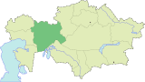 | |
| Major cities | ||
| Towns and villages |
| |
| Regions |  | |
|---|---|---|
| Special status cities | ||
| Authority control |
|---|