Aitkenvale, Queensland
Aitkenvale is a suburb of Townsville in the City of Townsville, Queensland, Australia.[2]
| Aitkenvale Townsville, Queensland | |||||||||||||||
|---|---|---|---|---|---|---|---|---|---|---|---|---|---|---|---|
 View of roundabout at Elizabeth Street and Alfred Street | |||||||||||||||
 Aitkenvale | |||||||||||||||
| Coordinates | |||||||||||||||
| Population | 4,790 (2016 census)[1] | ||||||||||||||
| • Density | 1,452/km2 (3,760/sq mi) | ||||||||||||||
| Postcode(s) | 4814 | ||||||||||||||
| Area | 3.3 km2 (1.3 sq mi) | ||||||||||||||
| LGA(s) | City of Townsville | ||||||||||||||
| State electorate(s) | Mundingburra | ||||||||||||||
| Federal Division(s) | Herbert | ||||||||||||||
| |||||||||||||||
History
Aitkenvale is situated in the traditional Wulgurukaba Aboriginal country.[3]
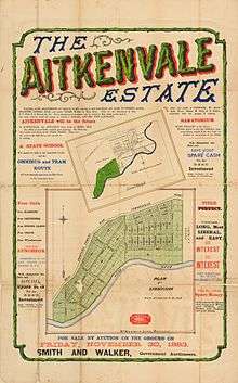
The suburb is named after Thomas Aitken, the original grantee of Portion 38, Parish of Coonambelah. He began subdividing the property during the 1880s, putting 440 quarter-acre residential allotments on the market in 1885. A dairy farm was established in the region by Thomas Aitken in about 1867, the two remaining buildings of this farm (described as the Herdsman's Cottage and Cordial Factory) are still standing on what is now Leopold Street adjacent to Ross River.[2]
The Aitkenvale public library opened in 1971.[4]
Present day
Aitkenvale is now a major commercial and residential district of the city. The suburb is home to two of Townsville's biggest shopping centres and is home to branches of numerous companies. Aitkenvale is the biggest commercial centre in Townsville outside of the Townsville CBD, and is often referred to as the second CBD. Besides offices and shopping centres, the suburb is mainly residential and has some light industrial warehouses and workshops in the top north-eastern corner of the suburb. There is also picturesque parkland along the bank of the Ross River.
The suburb was significantly affected by the 2019 Townsville flood with riverside areas around Thompson Street inundated, along with Ross River Road adjacent to the Aitkenvale Library where floodwaters claimed two lives.[5]
Population
According to the 2016 census of Population, there were 4,790 people in Aitkenvale.
- Aboriginal and Torres Strait Islander people made up 6.7% of the population.
- 73.3% of people were born in Australia.
- 79.0% of people only spoke English at home. Other languages spoken at home included Somali at 2.2%.
- The most common responses for religion were No Religion 27.0%, Catholic 23.8% and Anglican 14.0%.[1]
Public Facilities in Aitkenvale
- Education
- Public Facilities
- Parks
- Aitkenvale Park
- Rossiter Park
- Henrietta Park
- Public Libraries
- CityLibraries Aitkenvale at 4 Petunia Street, operated by CityLibraries Townsville [9]
- Sporting Grounds
- Illich Park (Centrals Rugby League)
- Parks
- Shopping
- Stockland Townsville
- Myer
- Big W
- Kmart
- Coles
- Woolworths
- 205 Specialties Stores
- Stockland Townsville
References
- Australian Bureau of Statistics (27 June 2017). "Aitkenvale (State Suburb)". 2016 Census QuickStats. Retrieved 14 January 2018.

- "Aitkenvale (entry 44562)". Queensland Place Names. Queensland Government. Retrieved 14 March 2014.
- "Traditional Landowners - History and Heritage". Retrieved 25 June 2020.
- "Public Libraries Statistical Bulletin 2016-17" (PDF). Public Libraries Connect. State Library of Queensland. November 2017. p. 16. Archived (PDF) from the original on 30 January 2018. Retrieved 29 January 2018.
- "Cops looking into fatal police flood chase". NewsComAu. 5 February 2019. Archived from the original on 20 March 2019. Retrieved 18 April 2019.
- "Aitkenvale State School". Archived from the original on 2 February 2017. Retrieved 25 January 2017.
- "Opening and closing dates of Queensland Schools". Queensland Government. Retrieved 18 April 2019.
- "Riverside Adventist Christian School". Archived from the original on 2 February 2017. Retrieved 25 January 2017.
- "Townsville CityLibraries Aitkenvale". plconnect.slq.qld.gov.au. State Library of Queensland. Archived from the original on 21 March 2019. Retrieved 22 January 2018.