Ahe
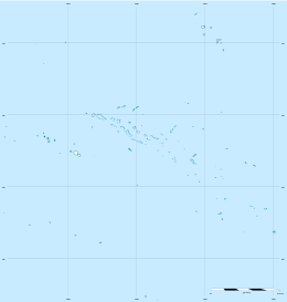
Ahe, Ahemaru or Omaru,[2] is an almost entirely-enclosed coral atoll, located in the northern Tuamotu Archipelago, just 14 km to the west of Manihi, in French Polynesia.
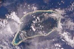 NASA picture of Ahe Atoll | |
 Ahe | |
| Geography | |
|---|---|
| Location | Pacific Ocean |
| Coordinates | 14°29′S 146°19′W |
| Archipelago | Tuamotus |
| Area | 138 km2 (53 sq mi) (lagoon) 12 km2 (5 sq mi) (above water) |
| Length | 23.5 km (14.6 mi) |
| Width | 12.2 km (7.58 mi) |
| Highest elevation | 10 m (30 ft) |
| Highest point | (unnamed) |
| Administration | |
France | |
| Overseas collectivity | French Polynesia |
| Administrative subdivision | Tuamotus |
| Commune | Manihi |
| Largest settlement | Tenukupara (pop. 100) |
| Demographics | |
| Population | 552[1] (2012) |
| Pop. density | 47/km2 (122/sq mi) |
Ahe Atoll's ring shape is broken by only a single small passage into the lagoon. Length 23.5 km, width 12.2 km. It has a land area of approximately 12 km2 and a lagoon area of 138 km2.
As of 2012, Ahe Atoll had 553 inhabitants. The only village in Ahe is Tenukupara with approximately 100 inhabitants. It is located on an island in the south side of the Atoll.[3]
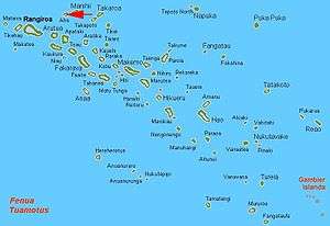
Geographically Ahe Atoll is part of the King George Islands (Iles du Roi Georges) subgroup, which includes Ahe, Manihi, Takapoto, Takaroa and Tikei.
There are several pearl farms in Ahe's lagoon.
In the late 1970s, the famous single-handed sailor Bernard Moitessier lived on Ahe for two years.[4]
History
The first recorded Europeans to arrive to Ahe Atoll were Dutch mariners Willem Schouten and Jacob Le Maire in 1616.
Ahe was later visited by the historic United States Exploring Expedition, 1838–1842.[5] Charles Wilkes called the atoll "Peacock Island" after one of the ships of the expedition.[6] This atoll has sometimes suffered damages caused by cyclones.[7]
Ahe has a territorial (domestic) airport which was inaugurated in 1997.
Demographics
Population of Ahe:
| 1977 | 1983 | 1988 | 1996 | 2002 | 2007 | 2012 | ||
|---|---|---|---|---|---|---|---|---|
| 109 | 142 | 162 | 377 | 441 | 566 | 552 | ||
| Sources ISPF,[8] Mairie de Ahe[9] * : estimation | ||||||||
Administration
Ahe Atoll belongs to the commune of Manihi, which consists of the atolls of Manihi and Ahe.[10]
Images and maps
.jpg) Image Source: Landsat S-06-10_2000 (1:100,000)
Image Source: Landsat S-06-10_2000 (1:100,000).jpg) Map Source: EVS Precision Map (1:100,000)
Map Source: EVS Precision Map (1:100,000)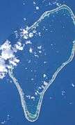 Image Source: ISS008-E-17141
- Image source: ISS007-E-16671
See also
References
- "Population". Institut de la statistique de la Polynésie française. Retrieved 23 September 2014.
- Young, J.L. (1899). "Names of the Paumotu Islands, with the old names so far as they are known". Journal of the Polynesian Society. 8 (4): 264–268. Retrieved 7 January 2015.
- "Oceandots - Ahe, Tuamotu Archipelago". Archived from the original on 2010-12-23. Retrieved 2009-03-14.
- Bernard Moitessier, Tamata and the Alliance (Sheridan Publishing, 1995)
- United States Exploring Expedition
- "[American Voyages, 1800 to 1842]". nzetc.org.
- Dupon, Jean-Francois (1984). "Where the exception confirms the rule: The cyclones of 1982–1983 in French Polynesia". Blackwell-synergy.com. 8 (1): 34–47. doi:10.1111/j.1467-7717.1984.tb00851.x. PMID 20958557.
- ISPF, Démographie Archived 2014-12-16 at the Wayback Machine
- Mairie de Ahe,
- Tahiti Tourisme Archived October 14, 2007, at the Wayback Machine (in French)
External links
| Wikimedia Commons has media related to Ahe. |
- Ahe Atoll FP (EVS Islands)
- Shuttle Image ISS008-E-17141 (Astronaut Photography)
- Shuttle Image ISS007-E-16671 (Astronaut Photography)
- Ahe Atoll FP (Oceandots.com) at the Wayback Machine (archived December 23, 2010)
- Tuamotu Atolls List (Pacific Image)
- TX5EG Amateur Radio DX Expedition to Ahe Atoll
Tuamotus Gambiers | Islands/Atolls | ||
|---|---|---|---|
| Island groups | |||