2016 Pensacola Tornado
On February 23, 2016, the northeastern side of Pensacola, Florida was struck by a powerful EF3 tornado that affected portions of southern Escambia County, Florida before continuing on into Santa Rosa County, Florida. The tornado formed as a result of a supercell that formed over the Gulf of Mexico, and moved northeastward onto Orange Beach, Alabama at 7:12 pm, producing the tornado almost an hour later. The tornado occurred as part of a much larger two-day outbreak of 61 tornadoes. Along with being the strongest of the outbreak, this was also the second EF3 tornado in Escambia County in about a week, with the first one striking Century, Florida.
| EF3 tornado | |
|---|---|
Part of the Tornado outbreak of February 23–24, 2016 and tornado outbreaks of 2016 | |
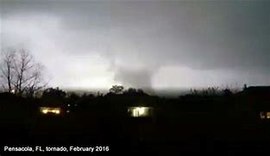 The tornado illuminated by lightning. | |
| Type | Tornado |
| Formed | February 23, 2016, 8:10 p.m. CST (UTC−06:00) |
| Duration | 11 minutes |
| Dissipated | February 23, 2016, 8:21 p.m. CST (UTC−06:00) |
| Max. rating1 | EF3 tornado |
| Highest winds |
|
| Damage | $22.075 million (2016 USD) |
| Casualties | 3 injuries [1] |
| Areas affected | Escambia and Santa Rosa County, Florida, especially Pensacola |
| 1Most severe tornado damage; see Enhanced Fujita scale | |
Meteorological Synopsis
The Storm Prediction Center in Norman, Oklahoma first included the north central Gulf Coast in a ‘slight risk’ area for severe thunderstorms three days prior to the event. As the details of the event came into focus by the 22nd, the area was upgraded to a moderate risk due to the possibility for long-tracked, significant (EF2+) tornadoes. The atmosphere was conducive for damaging storms as the afternoon and evening hours progressed on the 23rd. A deep trough of low pressure evolved into a closed low over eastern Texas and Arkansas with a strong wind maximum of 100 knots located to the south of the low center across the northern Gulf Coast. Strong diffluence ahead of this feature contributed to favorable conditions for lifting of unstable surface parcels in thunderstorm updrafts. At about 5000 feet above ground level (850mb), there was a 50-60 knot southerly Low Level Jet (LLJ) of air coming off the moist Gulf of Mexico. These strong winds brought copious moisture and contributed to very strong wind shear across the region.

This event was characterized by 50-60 knots of wind shear, more than sufficient for supercells with intense updraft rotation. In addition, there was strong turning and increasing wind speeds in the lowest 1km of the atmosphere, resulting in 400-500 m2/s2 of Storm Relative Helicity (SRH). These values meant that there was the possibility for strong to violent tornadoes that afternoon and evening Cold season severe events on the Gulf Coast are typically constrained by lack of instability. Widespread cloudiness preceded the event, leading to very little in the way of surface heating with CAPE values generally less than 1000 J/kg. However, given the extremely intense wind fields and favorable mid and upper level support for rising motion, these relatively low levels of instability were more than sufficient for severe thunderstorms and tornadoes. The National Weather Service in New Orleans launched a special sounding at noon on the 23rd that shows both sufficient instability and very strong wind shear. This environment advected across the National Weather Service in Mobile, Alabama area of responsibility during the afternoon and evening and is generally representative of conditions in which the severe thunderstorms formed.[1] Indeed, numerous strong, long-tracked tornadoes had already taken place in Louisiana, Mississippi, and Alabama, although less favorable conditions were causing a two-hour lull in tornadic activity.
Just before 7 pm CST, a strong supercell with intense low-level rotation was noted over the Gulf of Mexico, moving northeastward in the direction of Pensacola metro. At 7:12 pm CST, the National Weather Service in Mobile, Alabama issued a PDS tornado warning for Southeastern Baldwin County, Alabama and South Central Escambia County, Florida, with the warning stating "a large...extremely dangerous and potentially deadly tornado is developing."[2] The storm continued northeastward, although the rotation weakened without having produced a tornado. The NWS dropped the PDS tag at 7:54 pm CST, but continued the tornado warning as a tornado was still possible.[2] At 8:03 pm CST, the NWS put out an additional update that cancelled the warning for Baldwin County while stating that a possible tornado "was located over West Pensacola...moving northeast at 50 mph."[2] Seven minutes later, the tornado touched down.[3][4]
Tornado event
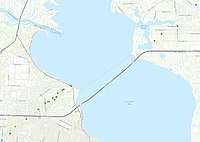
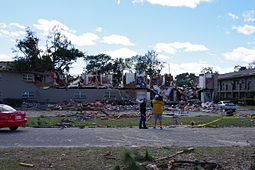
At 8:10 pm CST, the tornado first touched down southwest of SR 742 and immediately strengthened to EF2 intensity. Significant roof damage to several homes occurred along Lansing Drive along with several power poles being snapped and trees being damage. With their original warning on the storm set to expire at 8:15 pm CST and seeing that the rotation on radar had gotten stronger again, the NWS Mobile issued another PDS tornado warning for South Central Escambia and Southeastern Santa Rosa Counties at 8:11 pm CST, again stating that "a large...extremely dangerous and potentially deadly tornado is developing."[5] The tornado then weakened slightly before crossing the concurrent Interstate 10 and SR 8 as well as SR 289, inflicting EF1 damage to several hardwood trees. The tornado then restrengthened to EF2 intensity, and blew the roofs off two houses in two different neighborhoods. Two cars were also overturned along Tradewinds Drive. After this point, the tornado further intensified to EF3 status. Significant damage was inflicted to the Mooring Apartments on Old Spanish Trail Road with 24 units being destroyed due to their second floors being demolished. Six other units were damaged as well.[6] The tornado then reached its peak intensity of mid-range EF3 as it impacted a GE plant, completely destroying a warehouse with some of the debris from the area being found on the western shoreline of Escambia Bay in Santa Rosa County. Farther to the northeast along the shore of the Escambia Bay, two Grand Baroque townhouses along the concurrent US 90 and SR 10A were completely leveled and destroyed, with others in the area suffering damage as well.[3] The tornado then moved over Escambia Bay, where multiple vehicles were flipped and wrecked on the I-10 bridge.[7] This included an 18-wheeler that overturned.[8] The tornado then abruptly weakened before moving ashore in Avalon Beach in Santa Rosa County at EF1 intensity. The tornado then damaged multiple trees and homes near San Juan Street at Sealark Lane. It continued through the residential area, causing additional EF1 tree and minor home damage before lifting near Shetland Circle just west of Avalon Boulevard at 8:21 pm CST east-northeast of Mulat.[4] However, a debris ball was still present on radar, prompting the NWS Mobile to put out a more strongly worded update that stated that "a confirmed large and extremely dangerous tornado" was in progress while cancelling the warning for Escambia County at 8:23 pm CDT, two minutes after the tornado had lifted. The warning was eventually allowed to expire without any further updates at 8:45 pm CST.[5]
The tornado was on the ground for 11 minutes, traveled 8 miles (13 km), and had a maximum width of 300 yards (270 m). It had peak winds of 155 miles per hour (249 km/h), giving it a rating of mid-range EF3. Three people were injured and damages were estimated at $22.075 million (2016 USD).[3][4]
Aftermath
The same complex that produced this tornado continued to be tornado-warned until it reached Okaloosa County, Florida, although no tornadoes were reported. However, the supercells did reenter a favorable environment about two hours later, producing 10 weak tornadoes and prompting numerous tornado warnings in Southeastern Alabama and Southwestern Georgia, before eventually weakening for good after 1:27 am EST.[9][10]
Minutes after the EF3 tornado had passed, search and rescue officials were dispatched to the hardest hit areas of Pensacola, with the efforts continuing throughout the night. The Mooring Apartments was taped off to residents around 10 pm CST that night while rescue workers searched through the rubble.[11] The residents were bused to a shelter at Cokesbury United Methodist Church on Summit Boulevard, which had been opened by the American Red Cross a few hours earlier.[7] A number of roads, including Interstate 10 between mile markers 17 and 43, had to be shut down by the Florida Highway Patrol due to damage, downed trees and damaged vehicles.[6]
Gallery


See Also
- Hurricane Ivan tornado outbreak – Multiple tornadoes hit Escambia County
- Tornado outbreak of mid-October 2007 – An EF1 tornado struck Pensacola
References
- US Department of Commerce, NOAA. "2/23/2016 Tornado Event". www.weather.gov. Retrieved 2019-08-31.
- herzmann, daryl. "IEM :: Valid Time Event Code (VTEC) App". mesonet.agron.iastate.edu. akrherz@iastate.edu. Retrieved 7 July 2020.
- Florida Event Report: EF3 Tornado (Report). National Centers for Environmental Information. National Weather Service Weather Forecast Office in Mobile, Alabama. 2016. Retrieved May 26, 2016.
- Florida Event Report: EF1 Tornado (Report). National Centers for Environmental Information. National Weather Service Weather Forecast Office in Mobile, Alabama. 2016. Retrieved May 26, 2016.
- herzmann, daryl. "IEM :: Valid Time Event Code (VTEC) App". mesonet.agron.iastate.edu. akrherz@iastate.edu. Retrieved 7 July 2020.
- "PENSACOLA POUNDED: Apartment residents in shock". Pensacola News Journal.
- "Pensacola, Florida Tornado 2016: Pace, FL Tornado Approaching Milton". LALATE. 23 February 2016.
- US Department of Commerce, NOAA. "2/23/2016 Tornado Event". www.weather.gov.
- "The largest tornado outbreaks of 2016". U.S. Tornadoes. 29 February 2016.
- Georgia Event Report: EF1 Tornado (Report). National Centers for Environmental Information. National Weather Service Weather Forecast Office in Tallahassee, Florida. 2016. Retrieved May 29, 2016.
- "Suspected Tornado strikes Pensacola apartment complex". www.pnj.com.