1968 Pacific typhoon season
The 1968 Pacific typhoon season has no official bounds; it ran year-round in 1968, but most tropical cyclones tend to form in the northwestern Pacific Ocean between June and December. These dates conventionally delimit the period of each year when most tropical cyclones form in the northwestern Pacific Ocean.
| 1968 Pacific typhoon season | |
|---|---|
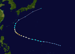
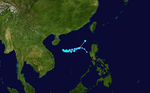
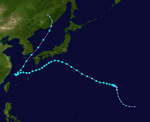
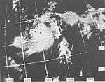
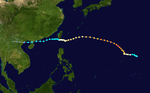
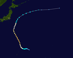
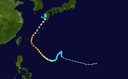
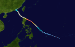
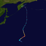
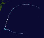
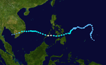
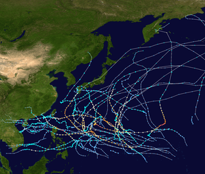 Season summary map | |
| Seasonal boundaries | |
| First system formed | January 21, 1968 |
| Last system dissipated | November 30, 1968 |
| Strongest storm | |
| Name | Agnes |
| • Maximum winds | 280 km/h (175 mph) (1-minute sustained) |
| • Lowest pressure | 900 hPa (mbar) |
| Seasonal statistics | |
| Total depressions | 39 |
| Total storms | 29 |
| Typhoons | 20 |
| Super typhoons | 4 (unofficial) |
| Total fatalities | 148 |
| Total damage | Unknown |
| Related articles | |
The scope of this article is limited to the Pacific Ocean, north of the equator and west of the international date line. Storms that form east of the date line and north of the equator are called hurricanes; see 1968 Pacific hurricane season. Tropical Storms formed in the entire west pacific basin were assigned a name by the Joint Typhoon Warning Center. Tropical depressions in this basin have the "W" suffix added to their number. Tropical depressions that enter or form in the Philippine area of responsibility are assigned a name by the Philippine Atmospheric, Geophysical and Astronomical Services Administration or PAGASA. This can often result in the same storm having two names.
Systems
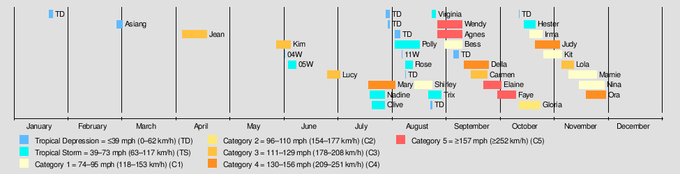
31 tropical depressions formed this year in the Western Pacific, of which 27 became tropical storms. 20 storms reached typhoon intensity, of which 4 reached super typhoon strength. No storms this season caused significant damage or deaths.
CMA Tropical Depression 01
| Tropical depression (CMA) | |
  | |
| Duration | January 21 – January 23 |
|---|---|
| Peak intensity | 55 km/h (35 mph) (10-min) 1002 hPa (mbar) |
This depression was not recognized by the JMA.
Tropical Depression 01W (Asiang)
| Tropical depression (JMA) | |
| Tropical storm (SSHWS) | |
 | |
| Duration | February 28 – March 2 |
|---|---|
| Peak intensity | 65 km/h (40 mph) (1-min) 999 hPa (mbar) |
Typhoon Jean
| Typhoon (JMA) | |
| Category 3 typhoon (SSHWS) | |
  | |
| Duration | April 5 – April 19 |
|---|---|
| Peak intensity | 205 km/h (125 mph) (1-min) 935 hPa (mbar) |
Typhoon Kim (Biring)
| Typhoon (JMA) | |
| Category 3 typhoon (SSHWS) | |
 | |
| Duration | May 28 – June 5 |
|---|---|
| Peak intensity | 185 km/h (115 mph) (1-min) 950 hPa (mbar) |
Tropical Depression 04W
| Tropical depression (JMA) | |
| Tropical depression (SSHWS) | |
 | |
| Duration | June 2 – June 2 |
|---|---|
| Peak intensity | 45 km/h (30 mph) (1-min) 1006 hPa (mbar) |
Tropical Depression 05W
| Tropical depression (JMA) | |
| Tropical storm (SSHWS) | |
 | |
| Duration | June 4 – June 8 |
|---|---|
| Peak intensity | 65 km/h (40 mph) (1-min) 1002 hPa (mbar) |
Typhoon Lucy (Konsing)
| Typhoon (JMA) | |
| Category 3 typhoon (SSHWS) | |
 | |
| Duration | June 26 – July 3 |
|---|---|
| Peak intensity | 205 km/h (125 mph) (1-min) 935 hPa (mbar) |
Typhoon Mary
| Typhoon (JMA) | |
| Category 4 typhoon (SSHWS) | |
  | |
| Duration | July 19 – August 3 |
|---|---|
| Peak intensity | 240 km/h (150 mph) (1-min) 925 hPa (mbar) |
Severe Tropical Storm Nadine (Didang)
| Severe tropical storm (JMA) | |
| Tropical storm (SSHWS) | |
 | |
| Duration | July 20 – July 28 |
|---|---|
| Peak intensity | 110 km/h (70 mph) (1-min) 970 hPa (mbar) |
Tropical Storm Olive (Edeng)
| Tropical storm (JMA) | |
| Tropical storm (SSHWS) | |
 | |
| Duration | July 21 – July 28 |
|---|---|
| Peak intensity | 85 km/h (50 mph) (1-min) 988 hPa (mbar) |
CMA Tropical Depression 11
| Tropical depression (CMA) | |
 | |
| Duration | July 29 – July 31 |
|---|---|
| Peak intensity | 55 km/h (35 mph) (10-min) 992 hPa (mbar) |
CMA Tropical Depression 12
| Tropical depression (CMA) | |
 | |
| Duration | July 30 – July 31 |
|---|---|
| Peak intensity | 55 km/h (35 mph) (10-min) 996 hPa (mbar) |
CMA Tropical Depression 13
| Tropical depression (CMA) | |
 | |
| Duration | August 3 – August 6 |
|---|---|
| Peak intensity | 45 km/h (30 mph) (10-min) 1003 hPa (mbar) |
Severe Tropical Storm Polly
| Severe tropical storm (JMA) | |
| Tropical storm (SSHWS) | |
  | |
| Duration | August 3 – August 17 |
|---|---|
| Peak intensity | 100 km/h (65 mph) (1-min) 965 hPa (mbar) |
Tropical Storm Polly dropped heavy rains on the southern islands of Japan. 112 people were killed and 21 were missing from the floods and landslides caused by Polly's heavy rains.[1]
On August 18, two sightseeing buses were involved in the landslide in Shirakawa, Gifu, it fell to the Hida River, and 95 persons died and 9 persons became missing(->see the Japanese article).
Tropical Depression 11W
| Tropical depression (JMA) | |
| Tropical depression (SSHWS) | |
 | |
| Duration | August 7 – August 7 |
|---|---|
| Peak intensity | 35 km/h (25 mph) (10-min) |
Severe Tropical Storm Rose (Gloring)
| Severe tropical storm (JMA) | |
| Tropical storm (SSHWS) | |
 | |
| Duration | August 9 – August 13 |
|---|---|
| Peak intensity | 110 km/h (70 mph) (1-min) 970 hPa (mbar) |
CMA Tropical Depression 16
| Tropical depression (CMA) | |
 | |
| Duration | August 9 – August 9 |
|---|---|
| Peak intensity | 35 km/h (25 mph) (10-min) 999 hPa (mbar) |
Typhoon Shirley (Huaning)
| Typhoon (JMA) | |
| Category 1 typhoon (SSHWS) | |
  | |
| Duration | August 14 – August 24 |
|---|---|
| Peak intensity | 120 km/h (75 mph) (1-min) 960 hPa (mbar) |
Severe Tropical Storm Trix (Iniang)
| Severe tropical storm (JMA) | |
| Tropical storm (SSHWS) | |
 | |
| Duration | August 22 – August 29 |
|---|---|
| Peak intensity | 100 km/h (65 mph) (1-min) 980 hPa (mbar) |
Tropical Storm Trix struck the southern islands of Kyūshū and Shikoku. Heavy flooding killed 25 people and left 2 missing.[1]
CMA Tropical Depression 18
| Tropical depression (CMA) | |
 | |
| Duration | August 23 – August 24 |
|---|---|
| Peak intensity | 45 km/h (30 mph) (10-min) 1000 hPa (mbar) |
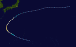
Severe Tropical Storm Virginia
| Severe tropical storm (JMA) | |
| Tropical storm (SSHWS) | |
 | |
| Duration | August 24 – August 26 (exited basin) |
|---|---|
| Peak intensity | 95 km/h (60 mph) (1-min) 990 hPa (mbar) |
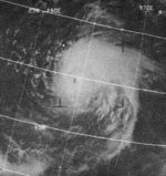
Virginia was first noticed near the International Date Line, about 500 kilometers (310 mi) northwest of Midway Islands. The system organized and the first advisory was issued on August 25 at 0006Z, with winds of 35 knots (40 mph). 18 hours later, Virginia crossed the date line, with winds of 50 knots (60 mph). It later became extratropical on August 27 in the Gulf of Alaska.
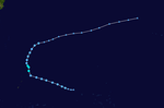
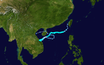
Typhoon Wendy (Lusing)
| Typhoon (JMA) | |
| Category 5 super typhoon (SSHWS) | |
  | |
| Duration | August 27 – September 10 |
|---|---|
| Peak intensity | 260 km/h (160 mph) (1-min) 920 hPa (mbar) |
Tropical Storm Wendy, which formed on August 28 in the open Western Pacific, quickly intensified to a peak of 160 mph winds on the 31st. It steadily weakened as it moved westward, and passed by southern Taiwan on September 5 as a minimal typhoon. Wendy continued to weaken, and after crossing the South China Sea, Wendy dissipated over northern Vietnam on the 9th.
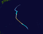
Typhoon Agnes
| Typhoon (JMA) | |
| Category 5 super typhoon (SSHWS) | |
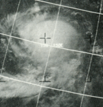  | |
| Duration | August 27 – September 10 |
|---|---|
| Peak intensity | 280 km/h (175 mph) (1-min) 900 hPa (mbar) |
Typhoon which did not approach land closely. The typhoon was one of two Category 5 cyclones to be named Agnes, the other being in 1952.
Typhoon Bess
| Typhoon (JMA) | |
| Category 1 typhoon (SSHWS) | |
 | |
| Duration | August 31 – September 10 |
|---|---|
| Peak intensity | 120 km/h (75 mph) (1-min) 965 hPa (mbar) |
CMA Tropical Depression 24
| Tropical depression (CMA) | |
 | |
| Duration | September 5 – September 8 |
|---|---|
| Peak intensity | 55 km/h (35 mph) (10-min) 990 hPa (mbar) |
Typhoon Carmen
| Typhoon (JMA) | |
| Category 3 typhoon (SSHWS) | |
 | |
| Duration | September 15 – September 24 |
|---|---|
| Peak intensity | 205 km/h (125 mph) (1-min) 935 hPa (mbar) |
Typhoon Della (Maring)
| Typhoon (JMA) | |
| Category 4 typhoon (SSHWS) | |
 | |
| Duration | September 11 – September 25 |
|---|---|
| Peak intensity | 220 km/h (140 mph) (1-min) 930 hPa (mbar) |
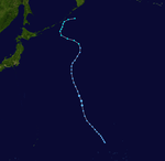
Typhoon Elaine (Nitang)
| Typhoon (JMA) | |
| Category 5 super typhoon (SSHWS) | |
 | |
| Duration | September 22 – October 2 |
|---|---|
| Peak intensity | 280 km/h (175 mph) (1-min) 910 hPa (mbar) |
Super Typhoon Elaine, after peaking at 175 mph winds, weakened to hit extreme northern Luzon on September 28 as a 130 mph typhoon. It continued to the northwest, and after hitting southeastern China as a minimal tropical storm Elaine dissipated on October 1.
Typhoon Faye
| Typhoon (JMA) | |
| Category 5 super typhoon (SSHWS) | |
  | |
| Duration | September 30 – October 10 |
|---|---|
| Peak intensity | 270 km/h (165 mph) (1-min) 915 hPa (mbar) |
Typhoon Gloria (Osang)
| Typhoon (JMA) | |
| Category 2 typhoon (SSHWS) | |
  | |
| Duration | October 12 – October 24 |
|---|---|
| Peak intensity | 165 km/h (105 mph) (1-min) 955 hPa (mbar) |
CMA Tropical Depression 29
| Tropical depression (CMA) | |
 | |
| Duration | October 12 – October 12 |
|---|---|
| Peak intensity | 45 km/h (30 mph) (10-min) 1006 hPa (mbar) |
Severe Tropical Storm Hester
| Severe tropical storm (JMA) | |
| Tropical storm (SSHWS) | |
 | |
| Duration | October 15 – October 21 |
|---|---|
| Peak intensity | 100 km/h (65 mph) (1-min) 995 hPa (mbar) |
Typhoon Irma
| Typhoon (JMA) | |
| Category 1 typhoon (SSHWS) | |
  | |
| Duration | October 18 – October 25 |
|---|---|
| Peak intensity | 150 km/h (90 mph) (1-min) 955 hPa (mbar) |
Typhoon Judy (Paring)
| Typhoon (JMA) | |
| Category 4 typhoon (SSHWS) | |
  | |
| Duration | October 21 – November 4 |
|---|---|
| Peak intensity | 220 km/h (140 mph) (1-min) 930 hPa (mbar) |
Typhoon Kit
| Typhoon (JMA) | |
| Category 1 typhoon (SSHWS) | |
  | |
| Duration | October 26 – November 5 |
|---|---|
| Peak intensity | 130 km/h (80 mph) (1-min) 960 hPa (mbar) |
Typhoon Lola
| Typhoon (JMA) | |
| Category 3 typhoon (SSHWS) | |
 | |
| Duration | November 5 – November 12 |
|---|---|
| Peak intensity | 195 km/h (120 mph) (1-min) 940 hPa (mbar) |
Typhoon Mamie (Reming)
| Typhoon (JMA) | |
| Category 1 typhoon (SSHWS) | |
  | |
| Duration | November 9 – November 25 |
|---|---|
| Peak intensity | 120 km/h (75 mph) (1-min) 975 hPa (mbar) |

Storm names
Western North Pacific tropical cyclones were named by the Joint Typhoon Warning Center. The first storm of 1968 was named Jean and the final one was named Ora.
|
|
|
|
Philippines
| Asiang | Biring | Konsing | Didang | Edeng |
| Gloring | Huaning | Isang | Lusing | Maring |
| Nitang | Osang | Paring | Reming | Seniang |
| Toyang | Undang (unused) | Welpring (unused) | Yoning (unused) | |
| Auxiliary list | ||||
|---|---|---|---|---|
| Aring (unused) | ||||
| Basiang (unused) | Kayang (unused) | Dorang (unused) | Enang (unused) | Grasing (unused) |
The Philippine Atmospheric, Geophysical and Astronomical Services Administration uses its own naming scheme for tropical cyclones in their area of responsibility. PAGASA assigns names to tropical depressions that form within their area of responsibility and any tropical cyclone that might move into their area of responsibility. Should the list of names for a given year prove to be insufficient, names are taken from an auxiliary list, the first 6 of which are published each year before the season starts. Names not retired from this list will be used again in the 1972 season. This is the same list used for the 1964 season, except for Didang, which replaced Dading. PAGASA uses its own naming scheme that starts in the Filipino alphabet, with names of Filipino female names ending with "ng" (A, B, K, D, etc.). Names that were not assigned/going to use are marked in gray.
References
External links
- Japan Meteorological Agency
- Joint Typhoon Warning Center.
- China Meteorological Agency
- National Weather Service Guam
- Hong Kong Observatory
- Macau Meteorological Geophysical Services
- Korea Meteorological Agency
- Philippine Atmospheric, Geophysical and Astronomical Services Administration
- Taiwan Central Weather Bureau
- Digital Typhoon - Typhoon Images and Information
- Typhoon2000 Philippine typhoon website