Écrins National Park
Écrins National Park (French: Parc national des Écrins, pronounced [paʁk nasjɔnal dɛz‿ekʁɛ̃]) is one of the ten French national parks. It is located in the south-eastern part of France in the Dauphiné Alps south of Grenoble and north of Gap, shared between the départements of Isère and Hautes-Alpes.
| Écrins National Park | |
|---|---|
| Parc national des Écrins | |
IUCN category II (national park) | |
 Chamoissière Pics and Romanche River, Écrins national Park | |
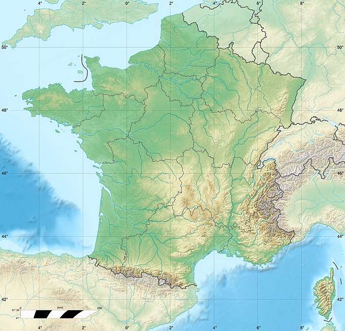 | |
| Coordinates | 44°51′21″N 6°15′49″E |
| Area | 918 km2 (354 sq mi) |
| Established | 1973 (1913) |
It rises up to 4,102 m (13,458 ft) at the Barre des Ecrins and covers 918 km2 (354 sq mi) of high mountain areas, with high peaks, glacier fields, glacier valleys, alpine pastures, subalpine woodlands and lakes.
Its borders mostly correspond to these of the Massif des Ecrins, delimited by the main valleys of rivers Drac, Romanche and Durance (with its Guisane dependency).
It attracts up to 800,000 tourists each year.
The park has been awarded the European Diploma of Protected Areas.
Territory
Écrins National Park covers the territory of the following communes:
Ancelle, Aspres-lès-Corps, Bénévent-et-Charbillac, Besse-en-Oisans, Buissard, Chabottes, Champcella, Champoléon, Chantelouve, Châteauroux-les-Alpes, Chauffayer, Clavans-en-Haut-Oisans, Crots, Embrun, Entraigues, Freissinières, L'Argentière-la-Bessée, La Chapelle-en-Valgaudémar, La Grave, La Motte-en-Champsaur, Lavaldens, Le Bourg-d'Oisans, Le Monêtier-les-Bains, Le Périer, Les Costes, Les Infournas, Les Vigneaux, Mizoën, Mont-de-Lans, Orcières, Oris-en-Rattier, Ornon, Oulles, Pelvoux, Prunières, Puy-Saint-Vincent, Puy-Saint-Eusèbe, Puy-Sanières, Réallon, Réotier, Saint-Apollinaire, Saint-Bonnet-en-Champsaur, Saint-Christophe-en-Oisans, Saint-Clément-sur-Durance, Saint-Eusèbe-en-Champsaur, Saint-Firmin, Saint-Jacques-en-Valgodemard, Saint-Jean-Saint-Nicolas, Saint-Julien-en-Champsaur, Saint-Léger-les-Mélèzes, Saint-Maurice-en-Valgodemard, Saint-Michel-de-Chaillol, Savines-le-Lac, Valbonnais, Valjouffrey, Vallouise, Vénosc, Villar-d'Arêne, Villard-Notre-Dame, Villard-Reymond, Villar-Loubière.

See also
External links
| Wikimedia Commons has media related to Écrins National park, France. |
| Metropolitan France | 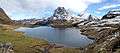 | |
|---|---|---|
| Overseas France | ||
| Authority control |
|
|---|