Ås, Norway
Ås is a municipality in Akershus in Viken county, Norway. It is part of the Follo traditional region. The administrative centre of the municipality is the village of Ås. The parish of Aas was established as a municipality on 1 January 1838 (see formannskapsdistrikt).
Ås kommune | |
|---|---|
 | |
 Coat of arms 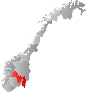 Viken within Norway | |
 Ås within Viken | |
| Coordinates: 59°39′37″N 10°47′1″E | |
| Country | Norway |
| County | Viken |
| District | Follo |
| Administrative centre | Ås |
| Area | |
| • Total | 103 km2 (40 sq mi) |
| • Land | 101.3 km2 (39.1 sq mi) |
| Area rank | 383 in Norway |
| Population (2020) | |
| • Total | 20,652 |
| • Density | 156.6/km2 (406/sq mi) |
| • Change (10 years) | 17.5% |
| Time zone | UTC+01:00 (CET) |
| • Summer (DST) | UTC+02:00 (CEST) |
| ISO 3166 code | NO-3021 |
| Official language form | Neutral[1] |
| Website | www |
Ås is one of the fastest-growing municipalities in Akershus, with a population of 20,652 in 2020, and an increase of 539 in 2008.[2] Ås is the largest agricultural municipality of Akershus, and home to the Norwegian University of Life Sciences and the amusement park Tusenfryd.
In February-March 2020, it was reported that a few incidents of the COVID-19 pandemic had occurred in Ås municipality and some inhabitants infected with the virus were placed in quarantine.[3]
General information
Etymology
The parish was named after the old Ås (Norse Áss) farm, since the first church was built there. The name is identical with the word áss meaning "hill", "ridge" or "esker" (height in moraine landscape). Prior to 1921, the name was spelled Aas.
Coat-of-arms
The coat-of-arms is from modern times. They were granted on 23 July 1982. The three silver diamonds are a symbol for the many archaeological findings in the area. The diamond (rhombus) shape was taken as it resembled many of the axes found in the area (Nøstvet ax). The silver colour resembles the flint, which the tools were made of. The number of three diamonds was chosen to represent the three parishes in the municipality: Ås, Kroer and Nordby.[4][5]
| Ancestry | Number |
|---|---|
| 521 | |
| 244 | |
| 214 | |
| 173 | |
| 161 | |
| 136 | |
| 134 | |
| 132 | |
| 122 | |
| 120 |
Economy
The most important source of income is agriculture. Ås is the largest agricultural municipality of Akershus: providing the region with grain, vegetables, and dairy products. Of the 101 square kilometres (39.0 sq mi) of land in the municipality, about 39 square kilometres (15.1 sq mi) are farmed and about 46 square kilometres (17.8 sq mi) are forested.[4]
Transportation
Ås Station is a train station served by the line 550 of the Oslo Commuter Rail, operated by the Norwegian State Railways. Two of Norway's largest highways, European route E6 and European route E18, run through the municipality, and many of the inhabitants commute to Oslo.

A 240-metre-long (787.4 ft) bridge, which is a smaller-scale recreation of a bridge that Leonardo da Vinci proposed in 1502 for the crossing of the Golden Horn, is located in the municipality. It was created by Norwegian painter and artist Vebjørn Sand as part of his Da Vinci project. The bridge serves as a pedestrian crossing over European route E18.
Population
As of 1 January 2020, Ås municipality covers 101.3 square kilometres (39 sq mi) and has 20,652 inhabitants.[2] In 2007, the Ås urban area had a population of 8,095.[7] The municipality also contains one additional urban area, Togrenda, with a population of 2,783. Also, 1,566 inhabitants live in the Ski urban area.
Notable residents
- Odd Tandberg (16 April 1924 – 14 February 2017) - painter, printmaker
- Øystein Wiik (born 1956) - actor, singer
- Christian Magnus Falsen (1782–1830) - Norwegian constitutional father
- Solveig Kringlebotn (born 1963) - soprano opera singer
Sister cities
The following cities are twinned with Ås:[8]

References
- "Forskrift om målvedtak i kommunar og fylkeskommunar" (in Norwegian). Lovdata.no.
- "Statistics Norway: Figures on Ås Municipality". Retrieved 12 May 2009.
- https://www.aasavis.no/nyheter/sykdom/helse/fire-personer-as-viser-symptomer-pa-smitte-skal-ha-vart-i-kontakt-med-koronarammet-avdeling-pa-ullevaal-sykehus/s/5-2-423533
- "Fakta om Ås kommune" (in Norwegian). Ås kommune. Retrieved 17 December 2008.
- Norske Kommunevåpen (1990). "Nye kommunevåbener i Norden". Retrieved 17 December 2008.
- "Immigrants and Norwegian-born to immigrant parents, by immigration category, country background and percentages of the population". ssb.no. Retrieved 25 June 2017.
- "Urban settlements. Population and area, by municipality". Statistics Norway. 1 January 2007. Archived from the original on 6 January 2008. Retrieved 6 March 2008.
- "Nyttige lenker i Ås". Ås kommune. Retrieved 28 April 2012.
External links
| Wikivoyage has a travel guide for Ås. |
| Wikimedia Commons has media related to Ås. |
| Look up Ås in Wiktionary, the free dictionary. |
 |  | ||||||||||||||||||||||||||||||||||||||||
|