Olden and Loen
Olden is a village in Sogn og Fjordane. This article also deals with the neighbour village Loen because they in practice are the same destination. They are both surrounded by high mountains, and at the fjord Nordfjord. The glacier Jostedalsbreen is not far away.
Understand

Olden and Loen are small villages at the intersection of deep lush valleys and the grand Nordfjord. These valleys are well known for their fine glaciers, all branches of Jostedalsbreen, the main glacier and the largest glacier in mainland Europe. The Olden and Loen valleys are also home to lovely lakes, rivers and waterfalls. The villages are on the shore of Nordfjord, some 8 km apart.
Get in
By plane
By car
Get around
See
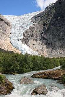
- 🌍 Briksdal glacier (Briksdalsbreen) (20 km (12 mi) from Olden, in the end of the valley), ☎ +47 57876800, fax: +47 57876801. Perhaps one of the most famous glacier in Norway. A part of Jostedalsbreen. The parking space is 2.5 km (1.6 mi) from the glacier. From there you could walk, or be transported with special cars. Transport road–glacier: Adults: 170 kr, Children: 65 kr.
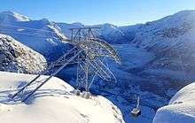
- 🌍 Loen Skylift (Road 60 (Stryn or Byrkjelo)). One of the few aerial tramways in Western Norway. Built only to offer visitors the best panorama of the lovely Loen/Olden area.
- 🌍 Kjendalen glacier (Kjendalsbreen). A branch of Jostedalsbreen glacier
- 🌍 Lodal lake (Lodalsvatnet). Lodalsvatnet is surrounded by high mountains. Because of small ice crystals, the water is sometimes green.
- Singerheimen, Olden, ☎ +47 57-87-31-06, e-mail: post@singerheimen.no. The home of the American explorer and painter William Singer. Hosts his paintings and collected artefacts.
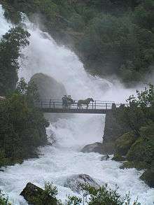
- Waterfalls, Olden. Lots of waterfalls add to the scenery. The one near the Tjugensetra village is simply breathtaking, but there are lots of more reachable ones.
Do


- Bike rental (Touristinformation). There are some quiet, and relatively flat roads.
- Glacier walking (Meet at Sande Camping), ☎ +47 57-87-68-00, +47 57-87-40-40. 10 Jun–15 Sep: at 10AM. A five hour trek, including three hours on the Bødalsbreen glacier. Children under twelve years are not allowed. 500 kr.
- Via Ferrata, Loen. A via ferrata starts behind the Hotel Alexandra and finishes at the top of Mount Hoven at 1010 meters.
- Hiking. Many hiking possibilities start from Loen. Signs indicate the hiking trails and their names. Respect the glacier. Keep away from its fronts and do not hike on it without an experienced guide.
- 🌍 Lovatnet walk. Jun–Oct (after last avalanches). Walk along the south-western lake shore on forest roads, with view to the mountains. 6.5 km (4.0 mi), 2 hours. Free.
- 🌍 Bødalsseter–Bødalsbreen (from Bødalen, south-east shore of Lovatnet). May–Oct. Easy hike up to a glacier arm. Mind the warnings, even if the view to the glacier itself may not be good, enjoy the landscapes on the way up. 3.4 km (2.1 mi), about one hour with start from the parking, about 15 km each way from Loen to there. Free.
- 🌍 Sande-Haugen/Tjugen setra–Sande (starts at forest road near Sande camping, some 6 km south-east from Loen, on the northern shore). May–Oct. Roundtrip on the fellside east of Lovatnet. Nice views, although not to the glacier. Requires some hiking experience, but is still suitable also for families, just be sure to keep to the trail. 7.4 km (4.6 mi), two hours, some 400 metres (1,300 ft) elevation gain. Free.
- 🌍 Skålatårnet (Skåla tower), Loen. Jul–Sep. Those with strong leg muscles can walk to the tower, on top of the mountain 1848 m (6063 ft). Needless to say, the view is magnificent. Car park at Tjugen as indicated on the map. DNT estimates needed time to 5 hours + breaks, for an experienced Norwegian hiker. Classified as a "black" hike, requiring fitness, skills and hiking equipment. The route is exposed in bad weather. Free.
Stay safe
Glaciers are treacherous and should be observed from safe distance only. Your life is at risk if walk near or on the glacier on your own.
On longer hikes there may be unexpected changes in weather, carry the gear you might need to cope.
Buy
Eat
Drink
Sleep
Budget
- Loen pensjonat, Loen, ☎ +47 57877624, fax: +47 57877678.
- Tjugen Camping, Loen, ☎ +47 57 87 76 17, e-mail: lill.tjugen@enivest.net. A nice camp site with a glacier view. It is also possible to rent cabins there. 165 NOK for a tent and two persons.
Mid-range
- Hotel Loenfjord, Loen, ☎ +47 57875700, fax: +47 57875751, e-mail: post@loenfjord.no.
- Olden Fjordhotell, Olden, ☎ +47 57870400, fax: +47 57870401, e-mail: post@olden-hotel.no.
Splurge
- Hotel Alexandra, Loen, ☎ +47 57875000, fax: +47 57875051, e-mail: alex@alexandra.no.
Connect
Go next
If you want to see more dramatic nature, Geiranger is a good choice.