Northern Canada
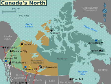
The North of Canada consists of three territories: Yukon, the Northwest territories, and Nunavut. They extend into the Arctic, and have just above 100.000 inhabitants spread across a land area larger than India.
Much of the population are Inuit (Eskimo) or members of other native First Nations; see Indigenous cultures of North America.
Territories

| Yukon The most accessible of the three territories with the Alaska Highway providing road links to Alaska and British Columbia. There is gold rush history in Dawson City and the mountainous splendour of Kluane National Park. Whitehorse, the capital, provides a good central hub. |
| Northwest Territories Previously the largest of all provinces and territories, parts of it have since been split of over the history of Canada, most recently Nunavut in 1999. |
| Nunavut Only split off from the Northwest Territories in 1999, this area has strong Inuit heritage |
Cities
In this area the term "city" becomes a relative term, especially when measured by population. However, some rather small places (by Southern standards) can have tremendous importance for huge areas as the only thing even approaching a city for hundreds or even thousands of miles. The most important places are:
Other destinations
Much of this area is untouched wilderness or sparsely populated mining and logging country. As such national parks have a natural draw to them, with North American wildlife. Examples include:
Understand
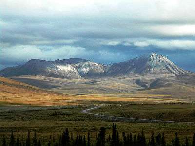
The North of Canada is a vast area made up of many different environments; ranging from boreal forest, to mountains, to subarctic all the way to high arctic. This is one of the most remote places on Earth and even the vast majority of Canadians will never visit the region. Travel here is extremely difficult and expensive. Most will want to visit during the summer when the territories aren't shrouded in near constant darkness, snow and freezing temperatures (to put it lightly). However, for those with the funds and motivation, visiting the North of Canada can be an extremely rewarding experience.
Get in
- See also: Next to impossible destinations

There are highways through the Yukon which reach Whitehorse, Dawson and even Inuvik. Another road goes to Yellowknife. All these roads are open year round but may be closed temporarily by storms; see winter driving.
Many other locations (including all of Nunavut) can only be accessed by sea or air. Flights to these areas can often be extremely expensive; see general aviation. A few cruise ships go to the Canadian arctic; this is likely the most comfortable way to visit.
Churchill, Manitoba (YYQ IATA) is reachable by rail and by air from Thompson and Winnipeg; from there, flights depart for Arviat, Baker Lake, Chesterfield Inlet, Coral Harbour, Rankin Inlet, Repulse Bay and Whale Cove.
Get around
Distances tend to be large and there are few roads and railways. Weather may impede movement during parts of the year and often access is only by boat or plane.
See
Do
Eat
Drink
Pay attention to your destination and research in advance whether alcohol is allowed. Some villages are dry communities (no alcohol permitted). Carrying alcohol into dry communities is considered to be bootlegging and you may be fined or imprisoned for violating this policy.
Stay safe
- See also: Winter in North America
There is no 9-1-1 emergency number in most communities in the Canadian high Arctic. As of 2016, the Yukon is making efforts to expand a very basic 9-1-1 (which is already available in Whitehorse) territory-wide. Elsewhere, 1-1-2 or 9-1-1 may merely reach a recording with no useful information.
Use the seven-digit local numbers for the individual services in each community to summon help in an emergency.
The articles cold weather, winter driving and dangerous animals all have advice which will be relevant to many travellers in the Arctic.