Lower Inn Valley
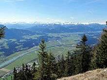
The Lower Inn Valley (German: Unterinntal) is the lower part of the Inn valley in Tyrol, Austria, stretching from a few km west of Innsbruck until Rosenheim in Germany.
Cities, towns and villages
| 🌍
Zirl (Zirl) |
| 🌍
Völs (Völs) |
| 🌍
Innsbruck (Innsbruck, Rum, Thaur) The capital of Tyrol and largest city in the Alps. |
| 🌍
Igls (Igls) Mountain town and ski resort near Innsbruck |
| 🌍
Hall in Tirol (Absam, Hall in Tirol, Mills) |
| 🌍
Wattens (Baumkirchen, Fritzens, Gnadenwald, Kolsass, Terfens, Volders, Wattens, Weer) Home to the Swarvoski Crystal Company |
| 🌍
Schwaz (Stans, Schwaz, Vomp) |
| 🌍
Jenbach (Jenbach, Wiesing) |
| 🌍
Brixlegg (Brixlegg, Kramsach, Münster, Radfeld, Rattenberg, Reith im Alpbachtal) |
| 🌍
Wörgl (Angath, Bad Häring, Angerberg, Kirchbichl, Kund, Langkampfen, Mariastein, Wörgl) |
| 🌍
Kufstein (Kufstein, Schwoich) |
Other destinations
Understand
History
The current distinction between Upper and Lower Inn Valley along the Melach corresponds to the old border between the district courts Sonnenburg and Hörtenberg. The Lower Inn Valley was first referred to as the Notitia Arnonis by Archbischop Arn from Salzburg in 788. Roman Emperor Conrad II awarded the Lower Inn Valley between Melach and Ziller in 1027, the named in Valle Eniana, to Bishop Hartwig of Brixen, which delegated the territory in 1165 to the Counts of Andechs. In 1248 the Lower Inn Valley eventually became under control of the Counts of Tyrol. The section west of the Ziller Valley was only annexed in 1504 after the War of the Succession of Landshut by decree of Emperor Maximilian I.

Climate
| Lower Inn Valley | ||||||||||||||||||||||||||||||||||||||||||||||||||||||||||||
|---|---|---|---|---|---|---|---|---|---|---|---|---|---|---|---|---|---|---|---|---|---|---|---|---|---|---|---|---|---|---|---|---|---|---|---|---|---|---|---|---|---|---|---|---|---|---|---|---|---|---|---|---|---|---|---|---|---|---|---|---|
| Climate chart (explanation) | ||||||||||||||||||||||||||||||||||||||||||||||||||||||||||||
| ||||||||||||||||||||||||||||||||||||||||||||||||||||||||||||
| ||||||||||||||||||||||||||||||||||||||||||||||||||||||||||||
The Lower Inn Valley lies in the transitional area between the drier inner alpine valley climate of the Upper Inn Valley (German: Oberinntal), and the rainy climate of the northern Alpine foothills in Bavaria. It has more rainfall and has more often a cloud cover than the Upper Inn Valley and its side valleys. Mist or high fog banks are common. Rainfall decreases westward in the valley, for example at Innsbruck Airport yearly rainfall averages to 883 mm, whereas Kufstein at the German border receives nearly 50% more with 1293 mm per year. In winter, the few degrees temperature difference between the west and east of the valley occasionally make the difference between snowfall in the west, and rain in the east.
Get in
By plane
The only airport in the valley is 🌍 Innsbruck Airport. From the airport, take bus F to 🌍 Innsbruck Hbf (Main Station), a ticket costs €2.40. From the Main Station, all other destinations in the valley can be reached by train.
The second nearest airport is 🌍 Munich Airport in Bavaria, Germany. There are high speed rail connections from Munich to Innsbruck.
By train
The Lower Inn Valley Railway (German: Unterinntalbahn) traverses the valley from Kufstein to Innsbruck where it splits in the Arlberg Railway and the Brenner Railway. It branches off into the Brixen Valley in Wörgl as the Salzburg-Tyrolean Railway. There are direct connections with Bozen, Munich, Vienna, and most other major cities in and around the Alps.
Get around
See
Do
Eat
Drink
Stay safe
Go next
- Upper Inn Valley (Telfs, Landeck)
- Ziller Valley
- Paznaun Valley
- Vorarlberg
- Bavaria, Germany