Central Belt
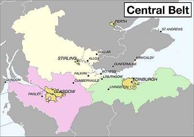
The Central Belt of Scotland is that part of the country which stretches from Glasgow in the west to Edinburgh in the east, and contains the majority of the population. The region varies greatly, from the country's two major cities and the ancient capital, Dunfermline, to the rural areas of the South Region.
Regions

Central Belt regions - Color-coded map
| Clydeside the area around Glasgow |
| The Lothians the area around Edinburgh |
| Stirlingshire and Clackmannanshire the mountainous, more rural county in the north of the region |
Cities and towns
Towns
- 🌍 Bo'ness (Gaelic: Ceann Fhàil)
- 🌍 Cumbernauld (Gaelic: Comar nan Allt)
- 🌍 Falkirk (Gaelic: An Eaglais Bhreac)
- 🌍 Linlithgow (Gaelic: Gleann Iucha)
- 🌍 Livingston (Gaelic: Baile Dhùn Lèibhe)
- 🌍 Paisley (Gaelic: Pàislig) – a town known for its textiles, the popular raindrop pattern is also named after this town.
Other destinations
- 🌍 Elderslie (Gaelic: Ach na Feàrna) – This is a small village between the towns of Paisley and Johnstone. It is the birthplace of William Wallace.
Understand
Get in
By car
Major roads into the Central Belt are:
- M74 bringing traffic from the northwest of England and southwest of Scotland to Glasgow
- A77 bringing traffic from the southwest of Scotland to Glasgow, via Ayr
- A1 bringing traffic from the northeast of England and southeast of Scotland to Edinburgh, via Berwick-upon-Tweed and Dunbar
- A7 & A68 bringing traffic from the Scottish Borders to Edinburgh
- A9 bringing traffic from the north of Scotland to Stirling, via Inverness and Perth
- A90 bringing traffic from Aberdeen and the northeast of Scotland to Edinburgh, via Dundee and Perth
Get around
See Scotland#Get around.
- ScotRail run the rail franchise in Scotland. A few cross border trains are run by other companies, but they operate long distance services and only stop in the larger rail stations.
Do
Eat
Drink
Sleep
Go next
- North to Scottish Highlands and North East Scotland
- South to South West (Scotland) and Scottish Borders
gollark: Or put in the neat thing for positive numbers with a conditional. Although I guess you'd still need both code paths.
gollark: Just use the magic incantation "without loss of generality".
gollark: Negative numbers can safely be ignored if inconvenient.
gollark: https://radio.osmarks.net/
gollark: Experience OIR™.
This article is issued from Wikivoyage. The text is licensed under Creative Commons - Attribution - Sharealike. Additional terms may apply for the media files.