Zutendaal
Zutendaal, in English sometimes also referred to as Sweet Valley, is a municipality located in the Belgian province of Limburg. On 1 January 2017 Zutendaal had a total population of 7,269. The total area is 32.07 km², giving a population density of 227 inhabitants per km².[3]
Zutendaal | |
|---|---|
 Flag  Coat of arms | |
 Zutendaal Location in Belgium
Location of Zutendaal in Limburg 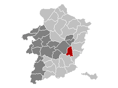 | |
| Coordinates: 50°56′N 05°34′E | |
| Country | Belgium |
| Community | Flemish Community |
| Region | Flemish Region |
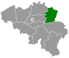
| Province | Limburg |
| Arrondissement | Hasselt |
| Government | |
| • Mayor | Ann Schrijvers (Nieuw ZVP)[1] |
| • Governing party/ies | Nieuw ZVP, Samen Zutendaal |
| Area | |
| • Total | 32.07 km2 (12.38 sq mi) |
| Population (2018-01-01)[2] | |
| • Total | 7,234 |
| • Density | 230/km2 (580/sq mi) |
| Postal codes | 3690 |
| Area codes | 089 |
| Website | www.zutendaal.be |
In addition to Zutendaal itself, the municipality includes the following population centres: Gewaai, Papendaal, Besmer, Broek, Stalken, Roelen, Daal, and Wiemesmeer.
Etymology
The first written mention of Zutendaal was in 1292 under the name of Suerbroeck, indicating that the land around the village was acidic and swampy. From 1345 the name changed to Zuetendael which literally translates to "Sweet Valley". Indicating there were a lot of freshwater sources around the village.[4]
Demographic evolution
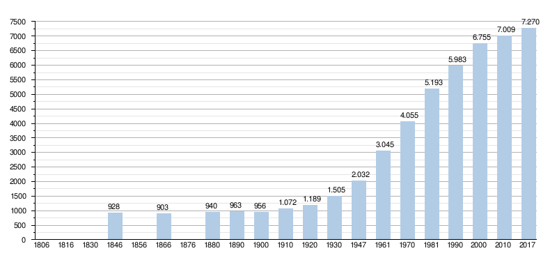
- Bronnen:NIS, Opm:1806 tot en met 1981=volkstellingen; 1990 en later= inwonertal op 1 januari
gollark: We've already hit the view cap, it seems.
gollark: I can do about four views/second, which should probably be enough since this stuff is generally capped by UVs.
gollark: I still can't access AoND myself.
gollark: Is the ND AR thing up?
gollark: Maybe AR-only ones turn out better? Who knows.
References
- samenstelling college van burgemeester en schepenen
- "Wettelijke Bevolking per gemeente op 1 januari 2018". Statbel. Retrieved 9 March 2019.
- "Zutendaal | Vlaanderen.be". vlaanderen.be.
- "Dialect en namen". users.telenet.be. Retrieved 2017-09-29.
External links

- Official website - Available only in Dutch
Places adjacent to Zutendaal | ||||||||||
|---|---|---|---|---|---|---|---|---|---|---|
| ||||||||||
This article is issued from Wikipedia. The text is licensed under Creative Commons - Attribution - Sharealike. Additional terms may apply for the media files.