Zmeitsa
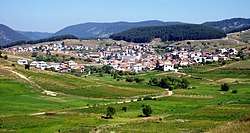
Zmeitsa (Bulgarian: Змейца) is a village in southwestern Bulgaria. It is located in the municipality of Dospat, Smolyan Province.
Zmeitsa Змейца | |
|---|---|
Village | |
 | |
 Zmeitsa Location of Zmeitsa | |
| Coordinates: 41°38′N 24°15′E | |
| Country | |
| Province (Oblast) | Smolyan |
| Municipality (Obshtina) | Dospat |
| Government | |
| • Mayor | Venelin Doikov (Social democrats) |
| Area | |
| • Total | 34.643 km2 (13.376 sq mi) |
| Elevation | 1,327 m (4,354 ft) |
| Population (2010-12-15)[2] | |
| • Total | 1,473 |
| Time zone | UTC+2 (EET) |
| • Summer (DST) | UTC+3 (EEST) |
| Postal Code | 4834 |
| Area code(s) | 03043 |
| Car plates | CM |
Geography
The village of Zmeitsa is located in the Western Rhodope Mountains. It is the easternmost settlement in the Chech region. The highest peak is Gioz Tepe - 1652 m.
Religion
Christian and Muslim
Public institutions
Local government office, library, kindergarten and school.
Notes
- http://results.cik.bg/tur2/mestni/2110_31259.html
- (in Bulgarian) Table of the population in Smolyan District
- "Archived copy". Archived from the original on July 21, 2011. Retrieved August 15, 2008.CS1 maint: archived copy as title (link)
gollark: No. APiohazards engaged.
gollark: > According to gollark, the pathfinding in EWO was really weird because it tried to be turing-complete. This led to the achievement “How the fuck did we get here?”, intended to be almost impossible to obtain, be achievable in less than 6 minutes, by getting all emus to target you and using another bug to provide infinite sticks. This was discovered by runner Andrew_the_Emu.> Due to a bug, it is possible to change certain stats about the character in the menu before entering the game, notably the number of emu kills recorded. This is referred to as “premuing”.These would be hard to implement.
gollark: Also transitive dependencies and silly people.
gollark: Because discord bad.
gollark: I've sent this reply.
This article is issued from Wikipedia. The text is licensed under Creative Commons - Attribution - Sharealike. Additional terms may apply for the media files.
