Zegveld
Zegveld is a village in the Dutch province of Utrecht. It is a part of the municipality of Woerden and lies about 5 km northwest of Woerden.
Zegveld | |
|---|---|
Town | |
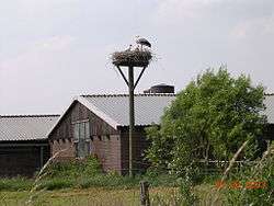 Ooievaarsdorp in Zegveld | |
 Coat of arms | |
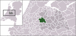 | |
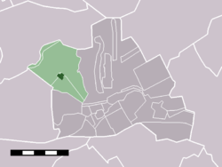 The village (dark green) and statistical district (light green) of Zegveld in the municipality of Woerden. | |
| Coordinates: 52°6′58″N 4°50′5″E | |
| Country | Netherlands |
| Province | Utrecht |
| Municipality | Woerden |
| Population (1 January 2010) | |
| • Total | 2,348 |
| Time zone | UTC+1 (CET) |
| • Summer (DST) | UTC+2 (CEST) |
In 2001 the town of Zegveld had 1,576 inhabitants. The built-up area of the town was 0.21 km2, and contained 563 residences.[1] The statistical district "Zegveld" has a population of around 2360.[2] This covers the entire former municipality, including the hamlets of Lagebroek and Stichtse Meije.
White storks
The village has a center for white storks to nest, a unique place in the area.
History
The village used to be a separate municipality. In 1989, it merged with Woerden. Unlike Woerden, Zegveld was always a part of the province of Utrecht.
gollark: You're supposed to minimise the average number of frustrated preferences for some reason.
gollark: I have no idea.
gollark: Apparently negative average preference utilitarianism is perfect and without flaw™ and fixes this somehow.
gollark: Worrying.
gollark: <@!543131534685765673> *Did* you?
References
- Statistics Netherlands (CBS), Bevolkingskernen in Nederland 2001 "Archived copy". Archived from the original on March 19, 2006. Retrieved January 24, 2007.CS1 maint: archived copy as title (link). Statistics are for the continuous built-up area.
- Statistics Netherlands (CBS), Statline: Kerncijfers wijken en buurten 2003–2005 "Archived copy". Archived from the original on July 24, 2006. Retrieved July 24, 2006.CS1 maint: archived copy as title (link). As of January 1, 2005.
External links
- J. Kuyper, Gemeente Atlas van Nederland, 1865-1870, "Zegveld". Map of the former municipality in 1868.
This article is issued from Wikipedia. The text is licensed under Creative Commons - Attribution - Sharealike. Additional terms may apply for the media files.