Zeevang
Zeevang (![]()
Zeevang | |
|---|---|
Former municipality | |
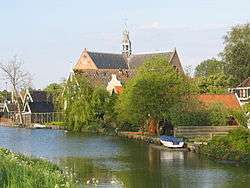 Church in Oosthuizen | |
 Flag Coat of arms | |
.svg.png) Location in North Holland | |
| Coordinates: 52°34′N 5°0′E | |
| Country | Netherlands |
| Province | North Holland |
| Municipality | Edam-Volendam |
| Established | 1970 (distablished in 2016) |
| Area | |
| • Total | 55.21 km2 (21.32 sq mi) |
| • Land | 38.06 km2 (14.70 sq mi) |
| • Water | 17.15 km2 (6.62 sq mi) |
| Elevation | −1 m (−3 ft) |
| Population (January 2019)[3] | |
| • Total | data missing |
| Time zone | UTC+1 (CET) |
| • Summer (DST) | UTC+2 (CEST) |
| Postcode | 1470–1477 |
| Area code | 0299 |
| Website | www |
Population centres
The former municipality of Zeevang consisted of the following cities, towns, villages and/or districts: Beets, Etersheim, Hobrede, Kwadijk, Middelie, Oosthuizen, Schardam, Warder.
Local government
The municipal council of Zeevang consisted of 13 seats, which were divided as follows (2015):
gollark: Now I have a planty dragon to name...
gollark: Smol?
gollark: I mean, it's free, but sounds weird.
gollark: Taken.
gollark: Does anyone have good names for a nebula which just hatched?
References
- "Kerncijfers wijken en buurten" [Key figures for neighbourhoods]. CBS Statline (in Dutch). CBS. 2 July 2013. Retrieved 12 March 2014.
- "Postcodetool for 1474HG". Actueel Hoogtebestand Nederland (in Dutch). Het Waterschapshuis. Retrieved 25 March 2014.
- "Bevolkingsontwikkeling; regio per maand" [Population growth; regions per month]. CBS Statline (in Dutch). CBS. 1 January 2019. Retrieved 1 January 2019.
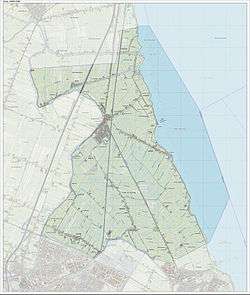
Map of the former municipality of Zeevang, September 2014
This article is issued from Wikipedia. The text is licensed under Creative Commons - Attribution - Sharealike. Additional terms may apply for the media files.