Zapicán
Zapicán is a village in the northwest of Lavalleja Department in Uruguay.
Zapicán | |
|---|---|
Village | |
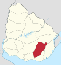
 Zapicán Location in Uruguay | |
| Coordinates: 33°31′39″S 54°56′21″W | |
| Country | |
| Department | Lavalleja Department |
| Founded | 1891 |
| Elevation | 231 m (758 ft) |
| Population (2011) | |
| • Total | 553 |
| Time zone | UTC -3 |
| Postal code | 30301 |
| Dial plan | +598 4463 (+4 digits) |
Location
The village is located on the junction of Route 14 with Route 40, about 24 kilometres (15 mi) east of José Batlle y Ordoñez, with an elevation of 231 m (758 ft).[1] The railroad track Montevideo - Nico Pérez - Río Branco passes along the south limits of the village.
History
It was founded by Pablo Fernández in September 1891 and on 9 June 1913, it was declared a "Pueblo" (village) by the Act of Ley Nº 4.337.[2]
Population
In 2011 Zapicán had a population of 553.[3]
| Year | Population |
|---|---|
| 1908 | 2.751 |
| 1963 | 839 |
| 1975 | 759 |
| 1985 | 670 |
| 1996 | 602 |
| 2004 | 640 |
| 2011 | 553 |
Source: Instituto Nacional de Estadística de Uruguay[2]
gollark: You should sleep because sleep is important for your health!
gollark: DO NOT DO IT!
gollark: Go `python3 sleep.py`.
gollark: Allegedly.
gollark: https://discord.com/channels/346530916832903169/348702212110680064/701951166908727426
References
- "American Museum - Novitates" (pdf). American Museum. 1994. Retrieved 6 September 2011.
- "Statistics of urban localities (1908–2004)" (PDF). INE. 2012. Archived from the original (PDF) on 5 November 2012. Retrieved 4 September 2012.
- "Censos 2011 Lavalleja (needs flash plugin)". INE. 2012. Retrieved 31 August 2012.
External links
Capital: Minas | ||
| Towns and villages |
|  |
| Sights | ||
This article is issued from Wikipedia. The text is licensed under Creative Commons - Attribution - Sharealike. Additional terms may apply for the media files.