Zacatonal
The Zacatonal is a montane grassland and shrubland ecoregion of central Mexico,[1] and Guatemala. The term is also used to refer to montane grasslands.
| Zacatonal | |
|---|---|
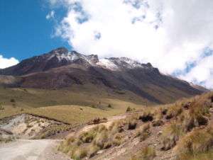 Zacatonal at the Nevado de Toluca | |
| Ecology | |
| Realm | Neotropical |
| Biome | montane grasslands and shrublands |
| Bird species | 204 |
| Mammal species | 48 |
| Geography | |
| Area | 306 km2 (118 sq mi) |
| Country | Mexico |
| Conservation | |
| Conservation status | Relatively Stable/Intact[1] |
Description
The Zacatonal consists of several enclaves of grassland and shrubland occupying the highest peaks of the Trans-Mexican Volcanic Belt, covering about 306 square kilometers (118 sq mi).
They are surrounded by the Trans-Mexican Volcanic Belt pine-oak forests ecoregion at lower elevations.
gollark: Hey, it's something.
gollark: Ideally, we'll have a wonderful, slow to dislodge mass of crazy.
gollark: Breeding to AP.
gollark: Yep <@284397085959258112>.
gollark: Why Not.
References
- "Zacatonal". Terrestrial Ecoregions. World Wildlife Fund. Retrieved 2013-08-24.
- World Wildlife Fund, ed. (2001). "Zacatonal". WildWorld Ecoregion Profile. National Geographic Society. Archived from the original on 2010-03-08.
This article is issued from Wikipedia. The text is licensed under Creative Commons - Attribution - Sharealike. Additional terms may apply for the media files.