Yeşilırmak (river)
The Yeşilırmak (Turkish: Yeşilırmak, "Green River"; classical Ancient Greek: Ἶρις, Iris) is a river in northern Turkey. From its source north-east of Sivas, it flows past Tokat and Amasya, and reaches the Black Sea at Samsun after 418 km (260 mi).
| Yeşilırmak River | |
|---|---|
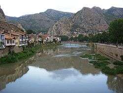 Yeşilırmak River in Amasya | |
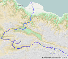 Map of Yeşilırmak | |
| Location | |
| Country | Turkey |
| Physical characteristics | |
| Source | |
| • location | Sivas |
| Mouth | |
• location | Black Sea |
• coordinates | 41°22′54″N 36°39′37″E |
• elevation | 0 m (0 ft) |
| Length | 418 km (260 mi) |
Its tributaries include the Çekerek (ancient Scylax) and the Kelkit (ancient Lycus).
It is mentioned by Menippus of Pergamon in the 1st century BC.[1][2]
Strabo's Geographica describes it as flowing through Comana Pontica, the plain of Dazimonitis (Kaşova) (40°17′41″N 36°17′48″E), and Gaziura (probably modern Turhal)[3] before receiving the waters (40°33′42″N 35°45′34″E) of the Scylax, then flowing through Amaseia (Amasya) before reaching the valley of Phanaroea.[4]
Notes
- Serena Bianchetti, Michele Cataudella, Hans-Joachim Gehrke, [Brill's Companion to Ancient Geography: The Inhabited World in Greek and Roman Tradition (BRILL, 4 Dec 2015) p 263.
- Georgia L. IrbyGeorgia L. Irby, A Companion to Science, Technology, and Medicine in Ancient Greece and Rome, 2 Volume Set (John Wiley & Sons, 2016) p 865.
- Phytoplankton and seasonal variations of the River Yeşilırmak, Amasya, Turkey (9 May 2003)
- Strabo 12:3:15 at Perseus
| Wikimedia Commons has media related to Yeşilırmak River. |
gollark: Sometimes I feel like going beyond ASCII was a mistake.
gollark: I mostly play indie games which do not immediately melt my laptop.
gollark: Specifically the "giant expensive ultra-realistic games" from big companies.
gollark: But some foolish ones do.
gollark: I'm not talking about THAT game.
This article is issued from Wikipedia. The text is licensed under Creative Commons - Attribution - Sharealike. Additional terms may apply for the media files.