Yandumblin, New South Wales
Yandumblin is a rural locality of Hay Shire Council and a civil parish of Nicholson County,[1][2] in the Riverina region of Australia.
Yandumblin, New South Wales
Geography
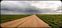
The parish located at 33°47′54″S 144°59′04″E is flat, semi-arid and the main economic activity is agriculture. The Parish 750 km (460 mi) from Sydney is on the Lachlan River and Yandumblin Creek. There are no towns in the parish though the town and river crossing of Booligal, New South Wales is just outside the parish.
History
Yandumblin is situated on the traditional boundary of the Muthi Muthi and Nari Nari Aboriginal tribes.
Pastoralists arrived in the area in the 1850s.[3] and the nearby town of Boooligal was established in July 1860.[4]
gollark: Also possibly patents and stuff are involved.
gollark: Ignorance of insecurity does not get you security, as my quotes library... contains.
gollark: "Security", yes.
gollark: I heard it was a cluster of some pine64 SBCs.
gollark: While I don't like systemd's overintegration, I have to admit the unit files are a pretty nice thing to have.
References
- Map of the County of Nicholson, New South Wales. Department of Lands, 1932.
- The New atlas of Australia (John Sands 1886) map 21.
- ‘Lower Murrumbidgee’ correspondent, Sydney Morning Herald, 31 March 1857, p. 3; Plain Facts of the One Tree Plain, compiled by Ruth K. Smith, 1977; ‘Recollections of Lang’s Crossing Place (Part II)’, Riverine Grazier, 22 December 1883; Crossley, Norman, Beyond the Lachlan: A History of Tom's Lake and the Crossley Family, 2005.
- Bushby, John E.P., Saltbush Country: History of the Deniliquin District, 1980, p. 152.
This article is issued from Wikipedia. The text is licensed under Creative Commons - Attribution - Sharealike. Additional terms may apply for the media files.