Wyoming Highway 95
Wyoming Highway 95 (WYO 95) is an overall east-west Wyoming State Road located in central Converse County and serves the towns of Glenrock, Rolling Hills, and areas northeast of those communities.
| ||||
|---|---|---|---|---|

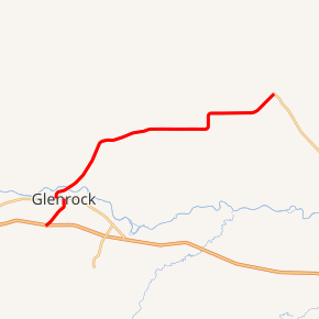
WYO 95 highlighted in red | ||||
| Route information | ||||
| Maintained by WYDOT | ||||
| Length | 19.23 mi[1] (30.95 km) | |||
| Western segment | ||||
| West end | ||||
| East end | ||||
| Eastern segment | ||||
| West end | ||||
| East end | ||||
| Location | ||||
| Counties | Converse | |||
| Highway system | ||||
State highways in Wyoming
| ||||
Route description
Wyoming Highway 95 begins its western (or southwestern) end at exit 165 of Interstate 25 and the northern end of Converse County Route 19.[2] WYO 95 travels from there northeasterly concurrent with I-25 BUS toward the town center of Glenrock as Deer Creek Road. WYO 95 passes the Glenrock Golf Course as it turns north and assumes the name S. 4th Street as it enters the town center.[2] WYO 95 intersects US 20/US 26/U.S. Route 87 in Wyoming (W. Birch Street) at 2.13-mile (3.4 km). I-25 Business heads south, following 20/26 east and 87 south. Wyoming 95 ends, not running concurrent with the US highways. WYO 95 resumes less than a mile west, just west of the Glenrock city limits.[3] WYO 95 turns northeast and curves around the northern side of Glenrock, crossing the North Platte River, and continuing northeast as Monkey Mountain Road. The town of Rolling Hills is reached north-northeast of Glenrock.[4] WYO 95 continues on its east-northeast track, named Glenrock-Ross Road east of Rolling Hills. WYO 95 turns north and back east again briefly near Carey before reaching its eastern terminus at Wyoming Highway 93 east of Carey.[4][5]
Major intersections
The entire route is in Converse County.
| Location | mi | km | Destinations | Notes | |||
|---|---|---|---|---|---|---|---|
| Glenrock | 0.00 | 0.00 | Western terminus; western terminus of concurrency with I-25 Bus.; exit 165 on I-25 | ||||
| 2.13 | 3.43 | Eastern terminus of concurrency with I-25 Bus. | |||||
| Use US 20 / US 26 / US 87 to connect between segments | |||||||
| 2.59 | 4.17 | ||||||
| | 19.23 | 30.95 | Eastern terminus | ||||
1.000 mi = 1.609 km; 1.000 km = 0.621 mi
| |||||||
References
- Wyoming @ AARoads.com - Wyoming Routes 000-099
- Streetview of WYO 95 at CR 19 (Map). Google Maps. Retrieved 2010-02-27.
- http://www.davidjcorcoran.com/highways/wy/wyroutes/?page_id=1401
- Google (14 August 2016). "Wyoming Highway 95 (via US 20/26/87)" (Map). Google Maps. Google. Retrieved 14 August 2016.
- Wyoming Department of Transportation Reference Marker Book - November 2004 (PDF) (Map). WYDOT. Archived from the original (PDF) on July 17, 2011. Retrieved 2010-03-01.
- Official 2003 State Highway Map of Wyoming
