Wyoming Highway 413
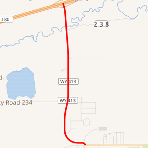
Wyoming Highway 413 (WYO 413) is a 2.73-mile-long (4.39 km) Wyoming state road in east-central Uinta County. WYO 413 provides a direct interstate connection for Lyman.
| ||||
|---|---|---|---|---|

WYO 413 highlighted in red | ||||
| Route information | ||||
| Maintained by WYDOT | ||||
| Length | 2.73 mi[1] (4.39 km) | |||
| Major junctions | ||||
| South end | ||||
| North end | ||||
| Location | ||||
| Counties | Uinta | |||
| Highway system | ||||
State highways in Wyoming
| ||||
Route description
Wyoming Highway 413 begins its southern end in the town of Lyman at Interstate 80 Business (East Clark Street/N. Main Street). From there Highway 413 curves north and passes east of the Rollins Reservoir and the local Lyman KOA before crossing the Blacks Fork River before reaching Interstate 80 at exit 41 where the state highway ends. The roadway continues north past the interstate as Uinta CR 231. [2][3]
Major intersections
The entire route is in Uinta County.
| Location | mi | km | Destinations | Notes | |
|---|---|---|---|---|---|
| Lyman | 0.00 | 0.00 | Southern terminus of WYO 413 | ||
| | 2.72 | 4.38 | Northern terminus of WYO 413 Exit 41 (I-80) | ||
| 1.000 mi = 1.609 km; 1.000 km = 0.621 mi | |||||
gollark: Generally, you punish the actual harm directly.
gollark: Besides, that isn't even particularly true for many of them.
gollark: They could cause you to cause harm to other people, but so can a lot of things, so I don't think this is a reasonable standard.
gollark: If you own your own body, I would assume that this includes being able to put drugs in it.
gollark: I doubt this? Basically all governments impose restrictions on e.g. drugs.
References
- Wyoming Department of Transportation Reference Marker Book - November 2004 (PDF) (Map). WYDOT. Archived from the original (PDF) on July 17, 2011. Retrieved 2011-10-19.
- Google (4 December 2011). "Overview Map of Wyoming Highway 413" (Map). Google Maps. Google. Retrieved 4 December 2011.
- Wyoming @ AARoads.com - Wyoming Routes 400-499
This article is issued from Wikipedia. The text is licensed under Creative Commons - Attribution - Sharealike. Additional terms may apply for the media files.
