Wyoming Highway 35
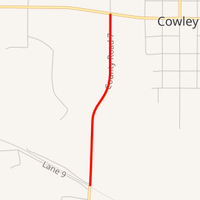
Wyoming Highway 35 (WYO 35) is a short 1.08-mile-long (1.74 km) north–south Wyoming state highway located in northwestern Big Horn County in Cowley.
| ||||
|---|---|---|---|---|
| Road 7[1] | ||||

WYO 35 highlighted in red | ||||
| Route information | ||||
| Maintained by WYDOT | ||||
| Length | 1.08 mi[2] (1.74 km) | |||
| Major junctions | ||||
| South end | ||||
| North end | ||||
| Location | ||||
| Counties | Big Horn | |||
| Highway system | ||||
State highways in Wyoming
| ||||
Route description
Wyoming Highway 35 is a spur route from U.S. Route 310/Wyoming Highway 789 (W. Main Street) in Cowley that heads south into some ranching areas southwest of Cowley.[2] The WYO 35 designation ends at 1.08 miles as the roadway crosses railroad tracks and becomes Big Horn County Road R7 near the intersections of Road 5 and Road 7.[1] Big Horn CR 5 continues south to Byron, and Road 7 continues southeast back to US 310/WYO 789 near Lovell.
Major intersections
The entire route is in Cowley, Big Horn County.
| mi | km | Destinations | Notes | ||
|---|---|---|---|---|---|
| 0.00 | 0.00 | Southern terminus | |||
| 1.08 | 1.74 | Northern terminus | |||
| 1.000 mi = 1.609 km; 1.000 km = 0.621 mi | |||||
gollark: Fascinating.
gollark: There are fancier and possibly more accurate ways to explain this but I can't currently be bothered.
gollark: `x mod y` is just the remainder when `x` is divided by `y`.
gollark: While you're here, consider some x where x^2 mod 384 = 8.3. Continue considering it. This is NOT to distract you.
gollark: So they should line up.
References
- Overview Map of Wyoming Highway 35 (Map). Google Maps. Retrieved 2010-02-02.
- Wyoming @ AARoads.com - Wyoming Routes 000-099
- Official 2003 State Highway Map of Wyoming
This article is issued from Wikipedia. The text is licensed under Creative Commons - Attribution - Sharealike. Additional terms may apply for the media files.
