Wyoming Highway 337
Wyoming Highway 337 (WYO 337) is a 1.54-mile-long (2.48 km) east-west Wyoming State Road located in central Sheridan County.
| ||||
|---|---|---|---|---|
| Fort Road | ||||
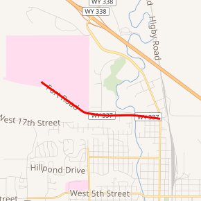
WYO 337 highlighted in red | ||||
| Route information | ||||
| Maintained by WYDOT | ||||
| Length | 1.54 mi[1] (2.48 km) | |||
| Major junctions | ||||
| West end | Fort MacKenzie Road in Sheridan | |||
| East end | ||||
| Location | ||||
| Counties | Sheridan | |||
| Highway system | ||||
State highways in Wyoming
| ||||

Route description
Wyoming Highway 337, locally named Fort Road, serves the Sheridan VA Medical Center in northwestern Sheridan.[2][3] WYO 337 begins its western end at Fort Mackenzie which is currently a hospital administered by the Veterans Administration. Traveling east, Highway 337 passes north of Thorne-Rider Park and crosses Big Goose Creek before reaching its eastern end at I-90 BUS/US 14 BUS/US 87 BUS (N. Main Street).[2][3]
Major intersections
The entire route is in Sheridan, Sheridan County.
| mi | km | Destinations | Notes | ||
|---|---|---|---|---|---|
| 0.00 | 0.00 | Fort MacKenzie Road | Western terminus of WYO 337 | ||
| 1.54 | 2.48 | Eastern terminus of WYO 337 | |||
| 1.000 mi = 1.609 km; 1.000 km = 0.621 mi | |||||
gollark: It's a switch-type thing which physically exists, but there aren't moving parts.
gollark: They aren't weird MEMS devices.
gollark: But cost per transistor isn't falling as it did.
gollark: Density is still increasing, if maybe not at the same rate.
gollark: No. There is substantially more progress in roadmaps.
References
- Wyoming Department of Transportation Reference Marker Book - November 2004 (PDF) (Map). WYDOT. Archived from the original (PDF) on July 17, 2011. Retrieved 2010-02-23.
- Google (26 December 2016). "Wyoming Highway 337" (Map). Google Maps. Google. Retrieved 26 December 2016.
- aaroads.com - Wyoming Highway 337
External links
This article is issued from Wikipedia. The text is licensed under Creative Commons - Attribution - Sharealike. Additional terms may apply for the media files.