Wyoming Highway 334
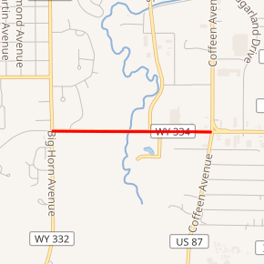
Wyoming Highway 334 (WYO 334) is a 0.74-mile-long (1.19 km) east-west Wyoming State Road in central Sheridan County that connects Wyoming Highway 332 with the business routes of I-90/US 14/US 87. In turn, those connect to exit 25 of Interstate 90 as well as US 14 and US 87.[2]
| ||||
|---|---|---|---|---|
| E. Brundage Lane | ||||

WYO 334 highlighted in red | ||||
| Route information | ||||
| Maintained by WYDOT | ||||
| Length | 0.74 mi[1] (1.19 km) | |||
| Major junctions | ||||
| South end | ||||
| North end | ||||
| Location | ||||
| Counties | Sheridan | |||
| Highway system | ||||
State highways in Wyoming
| ||||
Route description
Wyoming Highway 334 begins its western end at Wyoming Highway 332 (Big Horn Avenue) and travels east for just under eight-tenths of a mile to end at an intersection with I-90 BUS/US 14 BUS/US 87 BUS.[2][3] Exit 25 of Interstate 90 can be reached by continuing east along I-90 BUS/US 14 BUS/US 87 BUS another 0.3-mile (0.5 km).
The roadway itself continues west of WYO 332 as Sheridan County Route 34 to connect to Wyoming Highway 333 (Airport Road) and the Sheridan County Airport.[2][3]
Major intersections
The entire route is in Sheridan, Sheridan County.
| mi | km | Destinations | Notes | ||
|---|---|---|---|---|---|
| 0.00 | 0.00 | Western terminus of WYO 334 | |||
| 0.74 | 1.19 | Eastern terminus of WYO 334 | |||
| 1.000 mi = 1.609 km; 1.000 km = 0.621 mi | |||||
References
- Wyoming Department of Transportation Reference Marker Book - November 2004 (PDF) (Map). WYDOT. Archived from the original (PDF) on July 17, 2011. Retrieved 2010-02-17.
- Google (26 December 2016). "Wyoming Highway 334" (Map). Google Maps. Google. Retrieved 26 December 2016.
- aaroads.com - Wyoming Highway 334
