Wyoming Highway 152
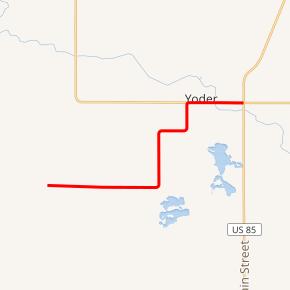
Wyoming Highway 152 (WYO 152) was a 9.80-mile-long (15.77 km) Wyoming State Road located in central Goshen County that served the community of Yoder and areas south and west of the community.
| ||||
|---|---|---|---|---|

WYO 152 highlighted in red | ||||
| Route information | ||||
| Maintained by WYDOT | ||||
| Length | 9.80 mi[1] (15.77 km) | |||
| Major junctions | ||||
| West end | CR 124 southwest of Yoder | |||
| East end | ||||
| Location | ||||
| Counties | Goshen | |||
| Highway system | ||||
State highways in Wyoming
| ||||
Route description
Wyoming Highway 152 began its western end southwest of Yoder at an intersection with three Goshen county routes; County Route 124 (west), County Route 128 (south), and County Route 202 (north).[2] From there Highway 152 headed east until it intersected the western terminus of Wyoming Highway 153, where then WYO 152 turned north towards Yoder.[3] WYO 152 turned east then north again before reaching Yoder and intersected the southern end of Wyoming Highway 154 in Yoder. WYO 154 heads west, as WYO 152 turned east and left Yoder, crossing the Fort Laramie Canal a mile before reaching its eastern end at an intersection with U.S. Route 85 and Wyoming Highway 161 just east of Yoder.[1][3]
Major intersections
The entire route is in Goshen County. [4]
| Location[4] | mi | km | Destinations | Notes | |
|---|---|---|---|---|---|
| | 0.00 | 0.00 | CR 124 | Continuation beyond western terminus | |
| | 3.94 | 6.34 | Western terminus of WYO 153 | ||
| | 7.85 | 12.63 | Southern terminus of WYO 154 | ||
| | 9.80 | 15.77 | |||
| Continuation beyond eastern terminus; western terminus of WYO 161 | |||||
| 1.000 mi = 1.609 km; 1.000 km = 0.621 mi | |||||
References
- Wyoming Department of Transportation Reference Marker Book - November 2004 (PDF) (Map). WYDOT. Archived from the original (PDF) on July 17, 2011. Retrieved 2011-03-24.
- Wyoming @ AARoads.com - Wyoming Routes 100-199
- Google (5 September 2016). "Wyoming Highway 152" (Map). Google Maps. Google. Retrieved 5 September 2016.
- Geography Division (2016). "Wyoming Governmental Unit Reference Map". United States Census Bureau. Retrieved January 23, 2017.
