Wyoming Highway 10
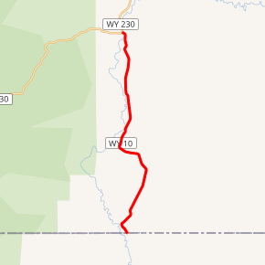
Wyoming Highway 10 (WYO 10) is a 9.12-mile-long (14.68 km) Wyoming state highway known as Jelm Mountain Road in southwestern Albany County.
| ||||
|---|---|---|---|---|
| Jelm Mountain Road | ||||

WYO 10 highlighted in red | ||||
| Route information | ||||
| Maintained by WYDOT | ||||
| Length | 9.12 mi[1] (14.68 km) | |||
| Major junctions | ||||
| South end | ||||
| North end | ||||
| Location | ||||
| Counties | Albany | |||
| Highway system | ||||
State highways in Wyoming
| ||||
Route description
WYO 10 is a north–south route that runs from Wyoming Highway 230 in Woods Landing south to the Wyoming-Colorado State Line and continues into Colorado as Larimer County Route 103. WYO 230 serves the Jelm Mountain Observatory (at an elevation 9656 feet). Mileposts along WYO 10 increase from north to south (0.00 to 9.12).[2] Wyoming Highway 10 is the lowest numbered state route in Wyoming.[1][3]
Major intersections
The entire route is in Albany County. [4]
| Location[4] | mi[2] | km | Destinations | Notes | |
|---|---|---|---|---|---|
| | 0.00 | 0.00 | Continuation beyond Colorado state line | ||
| Woods Landing-Jelm | 9.12 | 14.68 | |||
| 1.000 mi = 1.609 km; 1.000 km = 0.621 mi | |||||
gollark: Why do you need pip? Isn't it done by easy_install or something?
gollark: This is an x86 system, right?
gollark: Anyway, there are MANY extremely minor security vulnerabilities in kernel 4.19.0.
gollark: They changed their name to Helpiamtrappedinsimulationsbygtech, but nobody took it seriously.
gollark: Hmm, I think we *did* hire someone like that.
References
- Wyoming Routes 000–099
- Google (March 1, 2012). "Overview Map of Wyoming Highway 10" (Map). Google Maps. Google. Retrieved March 1, 2012.
- Wyomingroutes.org
- Geography Division (2016). "Wyoming Governmental Unit Reference Map". United States Census Bureau. Retrieved January 24, 2017.
This article is issued from Wikipedia. The text is licensed under Creative Commons - Attribution - Sharealike. Additional terms may apply for the media files.
