Wright's Ferry Bridge
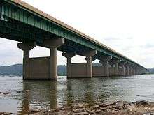
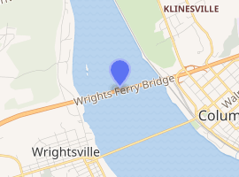
The Wright's Ferry Bridge carries U.S. Route 30 (US 30) over the Susquehanna River between Columbia and Wrightsville, Pennsylvania. The "Wright's Ferry" its name commemorates was the first ferry across the Susquehanna River. The bridge is considered the fifth Columbia–Wrightsville Bridge; it complements the fourth one, which still carries Lincoln Highway traffic.[notes 1]
Wright's Ferry Bridge | |
|---|---|
 | |
| Coordinates | 40.036°N 76.523°W |
| Carries | |
| Crosses | Susquehanna River |
| Locale | Wrightsville, Pennsylvania and Columbia, Pennsylvania |
| Other name(s) | Susquhanna River Bridge, Route 30 Bridge, Route 30 Intercounty Bridge |
| Maintained by | PennDOT |
| Characteristics | |
| Design | reinforced concrete and steel; divided four-lane highway |
| Longest span | 22 equal sections approximately 500ft long on two spans (11 each direction)on 45 piers |
| History | |
| Opened | November 21, 1972 |
| Statistics | |
| Toll | none |

| |
Also known informally and locally as the Route 30 bridge, it was commissioned by the Commonwealth of Pennsylvania in the 1960s to relocate US 30 and bypass the river towns of Wrightsville and Columbia. Construction started in March 1969 with G.A. & F.C. Wagman, Inc. as the general contractor.
The bridge was completed in 1972 at a cost of $12 million and opened November 21, 1972 under its present commemorative historical name, with Wright's Ferry being both the historic ferry's and one of Columbia's former names. It is constructed of reinforced concrete and steel and has 46 equal sections on 45 piers. US 30 crosses it as a divided four-lane roadway. About a year after its opening, the bridge was shut down briefly so that an experimental weather-resistant coating could be applied to its roadway. Tolls were never collected on this bridge, the sixth to have crossed the river in this general location.
References
- Columbia, the Gem, Bill Kloidt, Sr. 1994, Mifflin Press, Inc.
- Fire on the River, The Defense of the World’s Longest Covered Bridge and How It Changed the Battle of Gettysburg, George Sheldon, 2006, Quaker Hills Press, Inc. ISBN 0-9779315-0-1, 978-0-9779315-0-7.
Notes
- Many digital maps label the Route 30 stretch west of this bridge with the "Lincoln Highway" title, though it's Pennsylvania Route 462 west of the river – sometimes also labeled as such – that holds the proper identity as Lincoln Highway. (Smith, Stephen H. (March 27, 2013). "Haines Shoe House will be a June 23rd Lunch Stop on 100th Anniversary Lincoln Highway Auto Tour". York Daily Record. Retrieved February 8, 2016.
From The York Dispatch issue of Fri. Nov. 24, 1972 back page: With the opening of the full 20-miles extending from a point near Thomasville to Columbia on the Lancaster County side of the river, the new artery now becomes officially designated as U.S. 30... the hard-traveled highway now becomes Pennsylvania Traffic Route 462 but retains its nationwide identity as the Lincoln Highway.
)