Wonderland Trail
The Wonderland Trail is an approximately 93-mile (150 km)[1][2] hiking trail that circumnavigates Mount Rainier in Mount Rainier National Park, Washington, United States. The trail goes over many ridges of Mount Rainier for a cumulative 22,000 feet (6,700 m) of elevation gain.[1] The trail was built in 1915.[3] In 1981, it was designated a National Recreation Trail.[4] An estimated 200 to 250 people a year complete the entire trail[1] with several thousand others doing shorter sections of it. The average time taken to complete the entire trip is 10 to 14 days.[3]
| Wonderland Trail | |
|---|---|
The Cowlitz Divide portion of the trail, in the southeastern portion of the park, offers many views of Mt. Rainier and its numerous glaciers | |
| Length | 93 miles (150 km)[1][2] |
| Location | Mount Rainier National Park, Washington, United States |
| Trailheads | Longmire Mowich Lake Ipsut Creek Camp Ground Sunrise parking area White River Camp Ground Fryingpan Creek Trailhead Box Canyon Reflection Lakes Cougar Rock |
| Use | Hiking |
| Elevation | |
| Elevation gain/loss | 22,000 feet (6,700 m) gain approximately[1] |
| Highest point | Panhandle Gap 6,750 feet (2,060 m)[3] |
| Lowest point | Ipsut Creek Campground 2,320 feet (710 m)[1] |
| Hiking details | |
| Season | Summer to early fall |
| Months | Mid-July through late September |
| Website | nps.gov/mora/planyourvisit/the-wonderland-trail.htm |
The Trail
The trail is entirely within the national park and passes through major life zones of the park, from lowland forests to subalpine meadows of wildflowers. As the trail circles the mountain, hikers see different faces of Mount Rainier, carved by 25 named glaciers.
The trail is considered strenuous as it is almost always climbing or descending the ridges around the mountain. The highest point is 6,750 feet (2,060 m) at Panhandle Gap.[3]

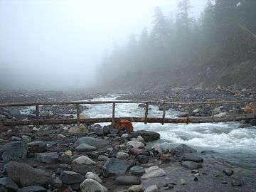
There are many river crossings on the trail including two suspension bridges. Many of the rivers are crossed on primitive log bridges which can wash away during heavy rain or when there is a lot of snow melt in the rivers. Most of the bridges washed away during a major storm in November 2006, so the trail was impassable (and closed) to hikers through most of 2007.
The main hiking season is late summer, which is often dry and sunny. However, Mount Rainier's high elevation and proximity to the Pacific Ocean can also bring moisture as rain or snow to the trail. In many years, the Wonderland Trail is still mostly snow-covered during June and early July.
The traditional route between Mowich Lake and the Carbon River is via Ipsut Pass and Ipsut Creek. Many people take an alternative route across Spray Park and Seattle Park, a higher elevation route that often lies under snow until late August.[5]
Complete trail descriptions may be found in a variety of trailbooks.[1][3][6]
Camping
Camping along the Wonderland Trail is extremely popular throughout the summer and wilderness camping reservations are essential for many of the most popular campsites. Eighteen trailside camps, 3 to 7 miles (5 to 11 km) apart, are located along the Wonderland Trail. Each camp has 1 to 8 sites for 1 to 5 persons per site. These sites will hold at most 2 tents. Parties requiring space for 3 or more tents must camp in a group site. Group sites are available at certain camps for parties of 6 to 12 persons. These sites typically hold 3 to 5 tents. Each camp has cleared tent sites, a pit or composting toilet, bear pole for hanging food, and a nearby water source.
Wilderness Camping Permits
A backcountry permit, including reservations for designated camping areas, is required to hike the Wonderland Trail. Advance reservations for permits can normally be submitted starting March 15 each year, with a lottery normally taking place on April 1 to attempt to meet the permit requests of as many as possible. The Wonderland Trail has become increasingly popular in recent years. In 2015, the park service stopped accepting applications in early April due to the overwhelming demand for permits.[7]
Due to the damage suffered as the result of a flood in November 2006 the park service did not accept reservations for the 2007 summer season for attempts to hike the entire Wonderland Trail. The trail was reopened on August 3, 2007 after extensive work by the park service, the Washington Conservation Corps, Student Conservation Association and 1,700 volunteers.[8]
See also
- Wonderland Trail Shelters
- Tour du Mont Blanc, a trail circling Mont Blanc in France, Switzerland, and Italy
References
- Filley, Bette (2002). Discovering the Wonders of the Wonderland Trail: Encircling Mount Rainier (5th ed.). Dunamis House. p. 52. ISBN 1-880405-09-1.
- "Wonderland Trail Profile". National Park Service. Retrieved 2016-09-13.
- Spring, Ira; Manning, Harvey (1999). 50 Hikes in Mount Rainier National Park. The Mountaineers. ISBN 0-89886-572-7.
- "Wonderland". American Trails. 2013-04-22. Retrieved 2014-08-14.
- Spring, Ira; Manning, Harvey (1998). 100 Classic Hikes in Washington. The Mountaineers. ISBN 0-89886-586-7.
- Smoot, Jeffrey L. (1991). Adventure Guide to Mount Rainier: Hiking, Climbing and Skiing in Mt. Rainier National Park. Falcon. ISBN 0-934641-40-4.
- Newberry, A.; Sparapani, M. (2016). Plan & Go: Wonderland Trail. sandiburg press. pp. 43–45. ISBN 978-1-943126-03-3.
- Wood, Terry (October 4, 2007). "Volunteer labor worth $1 million-plus helps rebuild Mount Rainier trails". Special to The Seattle Times. Retrieved 2007-10-12.
External links
| Wikimedia Commons has media related to Wonderland Trail. |