Wola Michowa
Wola Michowa [ˈvɔla mʲiˈxɔva] (Ukrainian: Воля Мигова, Volia Myhova) is a village in the administrative district of Gmina Komańcza, within Sanok County, in the Subcarpathian Voivodeship (province) of south-eastern Poland, close to the border with Slovakia.[1] It lies approximately 15 kilometres (9 mi) south-east of Komańcza, 36 km (22 mi) south of Sanok, and 90 km (56 mi) south of the regional capital Rzeszów.
Wola Michowa | |
|---|---|
Village | |
 Church | |
 Wola Michowa | |
| Coordinates: 49°14′N 22°9′E | |
| Country | |
| Voivodeship | Subcarpathian |
| County | Sanok |
| Gmina | Komańcza |
| Population | 90 |
The village has a population of 90.
Gallery
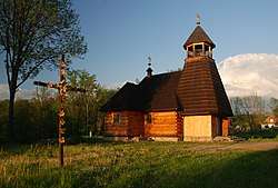
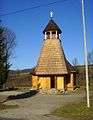 Newly constructed filial church in Wola Michowa
 Interior view of the church in Wola Michowa
gollark: The code is proprietary and you can't see it, but if you infer what's in it you can totally make PRs.
gollark: PRs welcome!
gollark: Storage, I said.
gollark: You utter and complete bee.
gollark: It was a pun.
See also
- Komancza Republic (November 1918 – January 1919)
References
This article is issued from Wikipedia. The text is licensed under Creative Commons - Attribution - Sharealike. Additional terms may apply for the media files.