Witenwasserenstock
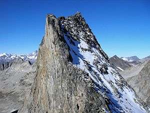
The Witenwasserenstock (3,082 m) is a peak between the Swiss cantons of Valais and Uri, located in the Lepontine Alps. Close to the summit lies the tripoint border between the cantons of Valais, Uri and Ticino and the triple watershed of the Rhine, Po and Rhône basins.
| Witenwasserenstock | |
|---|---|
 The summit | |
| Highest point | |
| Elevation | 3,085 m (10,121 ft) |
| Prominence | 118 m (387 ft) [1] |
| Parent peak | Pizzo Rotondo |
| Isolation | 0.41 km (0.25 mi) |
| Coordinates | 46°31′41.9″N 8°28′27.3″E |
| Geography | |
 Witenwasserenstock Location in Switzerland | |
| Location | Valais/Uri, Switzerland (mountain partially in Ticino) |
| Parent range | Lepontine Alps |
Geography and hydrography
The Witenwasserenstock lies between the valleys of Geretal (west) and Witenwasseren (north-east). At the foot of the mountain are located the Geren and Witenwasseren Glaciers. The tripoint between the cantons of Valais, Uri and Ticino (3,025 m) is located 300 m east from the summit. It acts as a notable watershed. On the west the Gerenwasser ends in the young Rhone, on the east the Witenwasserenreuss ends in the Reuss, a tributary of the Rhine and, on the east, the Ri di Bedretto ends in the Ticino (in the Leventina), a tributary of the Po.
- The Rhine enters the North Sea 670 km north.
- The Po enters the Adriatic Sea 360 km south-east.
- The Rhone enters the Mediterranean Sea 460 km south-west
See also
- Piz Lunghin a Swiss mountain triple watershed of Danube, Po and Rhine.
References
- Retrieved from the Swisstopo topographic maps . The key col is the Passo dei Sabbioni (2,967 m).