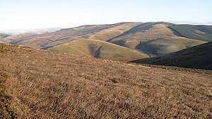
Windlestraw Law
Windlestraw Law is a hill in the Moorfoot Hills range, part of the Southern Uplands of Scotland. It is the highest peak of the range, and lies north of the town of Innerleithen in the Scottish Borders. A large and boggy peak, it is usually climbed from either its western slopes or the longer route from Tweeddale to the south.[4]
| Windlestraw Law | |
|---|---|
 | |
| Highest point | |
| Elevation | 659 m (2,162 ft) [1] |
| Prominence | 461 m (1,512 ft) [2] |
| Listing | Ma,Hu,Tu,Sim,G,D,DN,Y [3] |
| Coordinates | 55°40′39″N 3°00′03″W |
| Geography | |
| Location | Scottish Borders, Scotland |
| Parent range | Moorfoot Hills, Southern Uplands |
| OS grid | NT 37128 43091 |
| Topo map | OS Landranger 73 |
Subsidiary SMC Summits
| Summit | Height (m) | Listing[3] |
|---|---|---|
| Bareback Knowe [Windlestraw Law SW Top]] | 656 | DT,sSim[5] |
gollark: Linux *is the kernel*.
gollark: That... is not how it works.
gollark: 🇦 🇷 🇨 🇭
gollark: It is the best way.
gollark: ``` _______________________________________ < I can resist anything but temptation. > --------------------------------------- \ ^__^ \ (oo)\_______ (__)\ )\/\ ||----w | || ||```a cow.
References
- "Windlestraw Law". hill-bagging.co.uk. Retrieved 22 October 2019.
- "Windlestraw Law". www.hill-bagging.co.uk.
- "Database of British and Irish Hills: user guide". www.hills-database.co.uk.
- "Walkinghighlands Windlestraw Law". Walkinghighlands.co.uk. Retrieved 22 October 2019.
- "Bareback Knowe [Windlestraw Law SW Top]". www.hill-bagging.co.uk.
This article is issued from Wikipedia. The text is licensed under Creative Commons - Attribution - Sharealike. Additional terms may apply for the media files.